|
|
|
Specific Water Well Detail |
|
|
| Location Info | |||
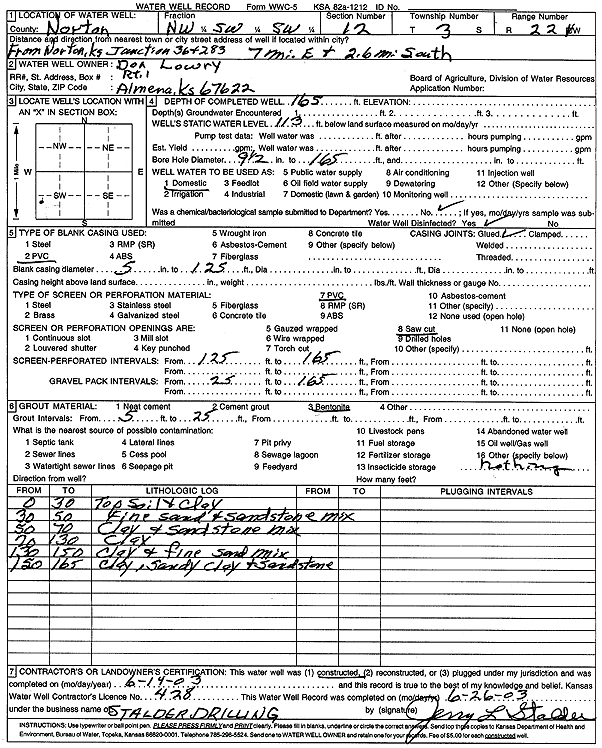
| Owner: Lowry, Don | Status: Constructed | ||
| Location: T3S, R22W, Sec. 12, NW SW SW | County: Norton | ||
| Directions: from Norton, Jct 36 and 283, 7 mi E and 2.6 mi S | |||
| Latitude: 39.8018028 | Longitude: -99.7564392 | Datum NAD 27 | |
| Latitude: 39.8018091 | Longitude: -99.756833 | Datum NAD 83 | |
| Longitude and latitude calculated by Survey from township-range-section-quarter calls. Only good to within the quarter call accuracy. | |||
| View well on interactive map | |||
| General Info | ||
| Well Depth: 165 ft. | Elevation: ft. | |
| Static Water Level: 113 ft. | Est. Yield: gpm. | |
| Comp. Date: 14-Jun-2003 | Well Use: Domestic | |
| DWR Applic. #: | Other ID: | |
| Driller Info | ||
| Driller: Leo J. Stalder Drilling | License #: 428 | |
| Scanned Form | View scan |
|
Chemical Sample Submitted?:
Water Well disinfected?: | ||
| Casing Info | ||
| Casing Type:
Casing Joints: |
Diam: in. to ft | |
| Casing height above land surface: in
Casing Weight: lbs/ft Wall thickness or gauge no.: | ||
| Screen and Perforation Info | ||
| Screen Type: | Screen Openings: | |
| Screen-perforated intervals | From: ft to ft | |
| Gravel pack intervals | From: ft to ft | |
| Grout Info | ||
| Grout used: | From: to ft | |
| Source of Possible Contamination | ||
| Source: | ||
| Direction from well: | Distance: ft | |
| Lithologic Log
(Log data entered by KGS.) | ||
| From: 0 ft. to 30 ft. | topsoil and clay | |
| From: 30 ft. to 50 ft. | fine sand and sandstone mix | |
| From: 50 ft. to 70 ft. | clay and sandstone mix | |
| From: 70 ft. to 130 ft. | clay | |
| From: 130 ft. to 150 ft. | clay and fine sand mix | |
| From: 150 ft. to 165 ft. | clay, sandy clay and sandstone | |