|
|
|
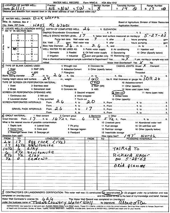
Specific Water Well Detail |
|
|
| Location Info | |||
| Owner: Werth, Dick | Status: Reconstructed | ||
| Location: T14S, R17W, Sec. 8, NE NW SW | County: Ellis | ||
| Directions: | |||
| Latitude: 38.8483851 | Longitude: -99.2401113 | Datum NAD 27 | |
| Latitude: 38.8483969 | Longitude: -99.2404895 | Datum NAD 83 | |
| Longitude and latitude calculated by Survey from township-range-section-quarter calls. Only good to within the quarter call accuracy. | |||
| View well on interactive map | |||
| General Info | ||
| Well Depth: 26 ft. | Elevation: ft. | |
| Static Water Level: 17 ft. | Est. Yield: 7 gpm. | |
| Comp. Date: 01-Jun-2003 | Well Use: Domestic, Lawn and Garden | |
| DWR Applic. #: | Other ID: | |
| Driller Info | ||
| Driller: Town & Country Water Well Service, LLC | License #: 626 | |
| Scanned Form | View scan |
|
Chemical Sample Submitted?:
Water Well disinfected?: | ||
| Casing Info | ||
| Casing Type:
Casing Joints: |
Diam: in. to ft | |
| Casing height above land surface: in
Casing Weight: lbs/ft Wall thickness or gauge no.: | ||
| Screen and Perforation Info | ||
| Screen Type: | Screen Openings: | |
| Screen-perforated intervals | From: ft to ft | |
| Gravel pack intervals | From: ft to ft | |
| Grout Info | ||
| Grout used: | From: to ft | |
| Source of Possible Contamination | ||
| Source: | ||
| Direction from well: | Distance: ft | |