|
|
|
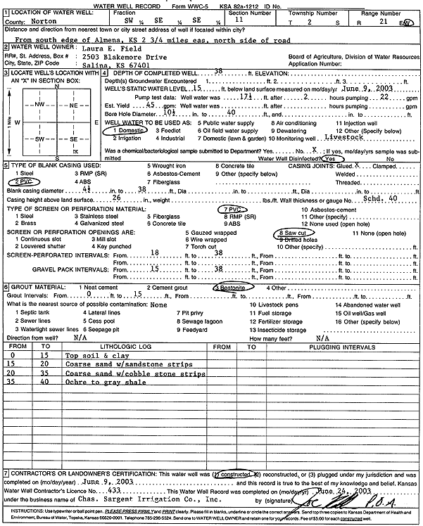
Specific Water Well Detail |
|
|
| Location Info | |||
| Owner: Field, Laura E. | Status: Constructed | ||
| Location: T2S, R21W, Sec. 11, SW SE SE | County: Norton | ||
| Directions: from S edge of Almena: 2.75 mi E, N side of Rd | |||
| Latitude: 39.8868299 | Longitude: -99.6491207 | Datum NAD 27 | |
| Latitude: 39.8868377 | Longitude: -99.6495093 | Datum NAD 83 | |
| Longitude and latitude calculated by Survey from township-range-section-quarter calls. Only good to within the quarter call accuracy. | |||
| View well on interactive map | |||
| General Info | ||
| Well Depth: 38 ft. | Elevation: ft. | |
| Static Water Level: 15 ft. | Est. Yield: 45 gpm. | |
| Comp. Date: 09-Jun-2003 | Well Use: Domestic, Livestock | |
| DWR Applic. #: | Other ID: | |
| Driller Info | ||
| Driller: Chas. Sargent Irrigation Co., Inc. | License #: 433 | |
| Scanned Form | View scan |
|
Chemical Sample Submitted?:
Water Well disinfected?: | ||
| Casing Info | ||
| Casing Type:
Casing Joints: |
Diam: in. to ft | |
| Casing height above land surface: in
Casing Weight: lbs/ft Wall thickness or gauge no.: | ||
| Screen and Perforation Info | ||
| Screen Type: | Screen Openings: | |
| Screen-perforated intervals | From: ft to ft | |
| Gravel pack intervals | From: ft to ft | |
| Grout Info | ||
| Grout used: | From: to ft | |
| Source of Possible Contamination | ||
| Source: | ||
| Direction from well: | Distance: ft | |
| Lithologic Log
(Log data entered by KGS.) | ||
| From: 0 ft. to 15 ft. | topsoil and clay | |
| From: 15 ft. to 20 ft. | coarse sand with sandstone strips | |
| From: 20 ft. to 35 ft. | coarse sand with cobble stone strips | |
| From: 35 ft. to 40 ft. | ochre to gray shale | |