|
|
|
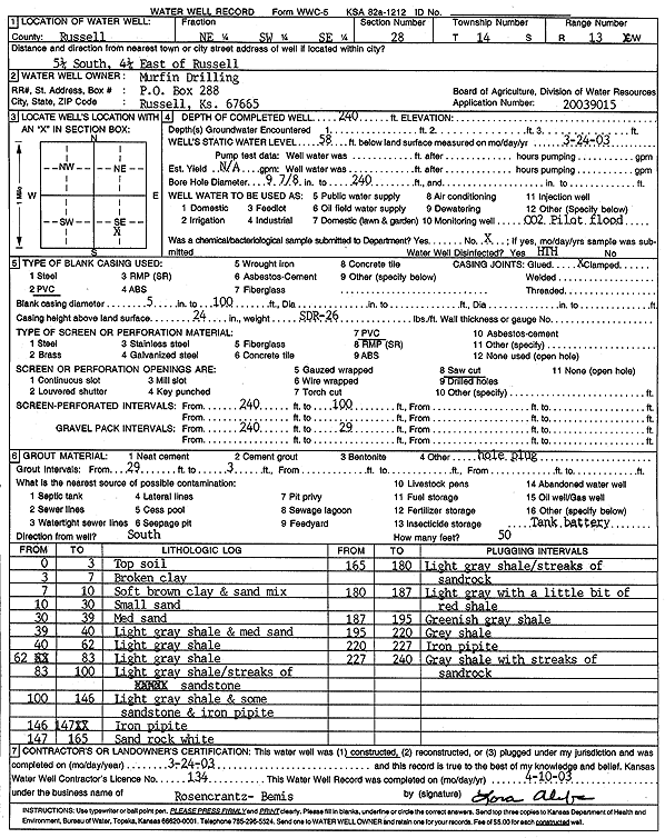
Specific Water Well Detail |
|
|
| Location Info | |||
| Owner: Murfin Drilling | Status: Constructed | ||
| Location: T14S, R13W, Sec. 28, NE SW SE | County: Russell | ||
| Directions: from Russell: 5.25 mi S, 4.25 mi E | |||
| Latitude: 38.8011763 | Longitude: -98.767818 | Datum NAD 27 | |
| Latitude: 38.8011876 | Longitude: -98.7681761 | Datum NAD 83 | |
| Longitude and latitude calculated by Survey from township-range-section-quarter calls. Only good to within the quarter call accuracy. | |||
| View well on interactive map | |||
| General Info | ||
| Well Depth: 240 ft. | Elevation: ft. | |
| Static Water Level: 58 ft. | Est. Yield: gpm. | |
| Comp. Date: 24-Mar-2003 | Well Use: Other (CO2 Pilot Flood) | |
| DWR Applic. #: 20039015 | Other ID: | |
| Links | |
| No Wizard information available. | |
| View info from WIMAS Water Right Data base... | |
| Driller Info | ||
| Driller: Rosencrantz-Bemis Enterprises, Inc. | License #: 134 | |
| Scanned Form | View scan |
|
Chemical Sample Submitted?: No
Water Well disinfected?: Yes | ||
| Bore hole diameter: 9.9 inches to 240 ft | ||
| Casing Info | ||
| Casing Type: PVC
Casing Joints: Glued |
Diam: 5 in. to 100 ft | |
| Casing height above land surface: 24 in
Casing Weight: lbs/ft Wall thickness or gauge no.: SDR 26 | ||
| Screen and Perforation Info | ||
| Screen Type: PVC | Screen Openings: Saw cut | |
| Screen-perforated intervals | From: 100 ft to 240 ft | |
| Gravel pack intervals | From: 29 ft to 240 ft | |
| Grout Info | ||
| Grout used: | From: 3 to 29 ft | |
| Source of Possible Contamination | ||
| Source: Oil well/gas well | ||
| Direction from well: South | Distance: 50 ft | |
| Lithologic Log
(Log data entered by KGS.) | ||
| From: 0 ft. to 3 ft. | top soil | |
| From: 3 ft. to 7 ft. | broken clay | |
| From: 7 ft. to 10 ft. | soft brown clay and sand mix | |
| From: 10 ft. to 30 ft. | small sand | |
| From: 30 ft. to 39 ft. | medium sand | |
| From: 39 ft. to 40 ft. | light gray shale and medium sand | |
| From: 40 ft. to 62 ft. | light gray shale | |
| From: 62 ft. to 83 ft. | light gray shale | |
| From: 83 ft. to 100 ft. | light gray shale with streaks of sandstone | |
| From: 100 ft. to 146 ft. | light gray shale and some sandstone and iron pyrite | |
| From: 146 ft. to 147 ft. | iron pyrite | |
| From: 147 ft. to 165 ft. | sand rock, white | |
| From: 165 ft. to 180 ft. | light gray shale with streaks of sand rock | |
| From: 180 ft. to 187 ft. | light gray with a little bit of red shale | |
| From: 187 ft. to 195 ft. | greenish gray shale | |
| From: 195 ft. to 220 ft. | gray shale | |
| From: 220 ft. to 227 ft. | iron pyrite | |
| From: 227 ft. to 240 ft. | gray shale with streaks of sand rock | |