|
|
|
Specific Water Well Detail |
|
|
| Location Info | |||
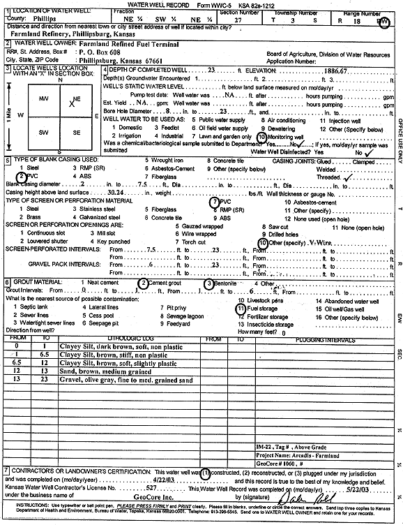
| Owner: Farmland Refined Fuel Terminal | Status: Constructed | ||
| Location: T3S, R18W, Sec. 27, NE SW NE | County: Phillips | ||
| Directions: Farmland Refinery, Phillipsburg | |||
| Latitude: 39.7657425 | Longitude: -99.3336628 | Datum NAD 27 | |
| Latitude: 39.7657522 | Longitude: -99.3340376 | Datum NAD 83 | |
| Longitude and latitude calculated by Survey from township-range-section-quarter calls. Only good to within the quarter call accuracy. | |||
| View well on interactive map | |||
| General Info | ||
| Well Depth: 23 ft. | Elevation: 1886.67 ft. | |
| Static Water Level: ft. | Est. Yield: gpm. | |
| Comp. Date: 22-Apr-2003 | Well Use: Monitoring well/observation/piezometer | |
| DWR Applic. #: | Other ID: IM 22 | |
| Driller Info | ||
| Driller: GeoCore Services Inc. | License #: 527 | |
| Scanned Form | View scan |
|
Chemical Sample Submitted?:
Water Well disinfected?: | ||
| Casing Info | ||
| Casing Type:
Casing Joints: |
Diam: in. to ft | |
| Casing height above land surface: in
Casing Weight: lbs/ft Wall thickness or gauge no.: | ||
| Screen and Perforation Info | ||
| Screen Type: | Screen Openings: | |
| Screen-perforated intervals | From: ft to ft | |
| Gravel pack intervals | From: ft to ft | |
| Grout Info | ||
| Grout used: | From: to ft | |
| Source of Possible Contamination | ||
| Source: | ||
| Direction from well: | Distance: ft | |
| Lithologic Log
(Log data entered by KGS.) | ||
| From: 0 ft. to 1 ft. | clayey silt, dark brown, soft, non plastic | |
| From: 1 ft. to 6.5 ft. | clayey silt, brown, stiff, non plastic | |
| From: 6.5 ft. to 12 ft. | clayey silt, brown, soft, slightly plastic | |
| From: 12 ft. to 13 ft. | sand, brown, medium grained | |
| From: 13 ft. to 23 ft. | gravel, olive gray, fine to medium grained sand | |