|
|
|
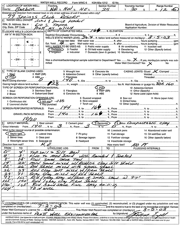
Specific Water Well Detail |
|
|
| Location Info | |||
| Owner: Perdue, John and Janice | Status: Constructed | ||
| Location: T30S, R12W, Sec. 25, NW NW NE | County: Barber | ||
| Directions: 99 Springs Club Resort | |||
| Latitude: 37.4120915 | Longitude: -98.5820059 | Datum NAD 27 | |
| Latitude: 37.4121121 | Longitude: -98.5823679 | Datum NAD 83 | |
| Longitude and latitude calculated by Survey from township-range-section-quarter calls. Only good to within the quarter call accuracy. | |||
| View well on interactive map | |||
| General Info | ||
| Well Depth: 166 ft. | Elevation: ft. | |
| Static Water Level: 36.4 ft. | Est. Yield: 4 gpm. | |
| Comp. Date: 02-Jul-2003 | Well Use: Domestic | |
| DWR Applic. #: | Other ID: | |
| Driller Info | ||
| Driller: Pratt Well Service, Inc. | License #: 665 | |
| Scanned Form | View scan |
|
Chemical Sample Submitted?:
Water Well disinfected?: | ||
| Casing Info | ||
| Casing Type:
Casing Joints: |
Diam: in. to ft | |
| Casing height above land surface: in
Casing Weight: lbs/ft Wall thickness or gauge no.: | ||
| Screen and Perforation Info | ||
| Screen Type: | Screen Openings: | |
| Screen-perforated intervals | From: ft to ft | |
| Gravel pack intervals | From: ft to ft | |
| Grout Info | ||
| Grout used: | From: to ft | |
| Source of Possible Contamination | ||
| Source: | ||
| Direction from well: | Distance: ft | |
| Lithologic Log
(Log data entered by KGS.) | ||
| From: 0 ft. to 4 ft. | top soil and silt, brown | |
| From: 4 ft. to 8 ft. | fine to medium sand with rounded and sorted | |
| From: 8 ft. to 14 ft. | fine sand, tan | |
| From: 14 ft. to 22 ft. | medium sand mixed with reddish clay, silt, and shale | |
| From: 22 ft. to 26 ft. | red shale mixed with small gravel | |
| From: 26 ft. to 29 ft. | red clay, soft, mixed with firm shale | |
| From: 29 ft. to 97 ft. | gray clay mixed with red shale | |
| From: 97 ft. to 115 ft. | red-gray clay with show of small sand at 97 feet | |
| From: 115 ft. to 150 ft. | red-gray clay, firm shale | |
| From: 150 ft. to 163 ft. | red sandstone, fine | |