|
|
|
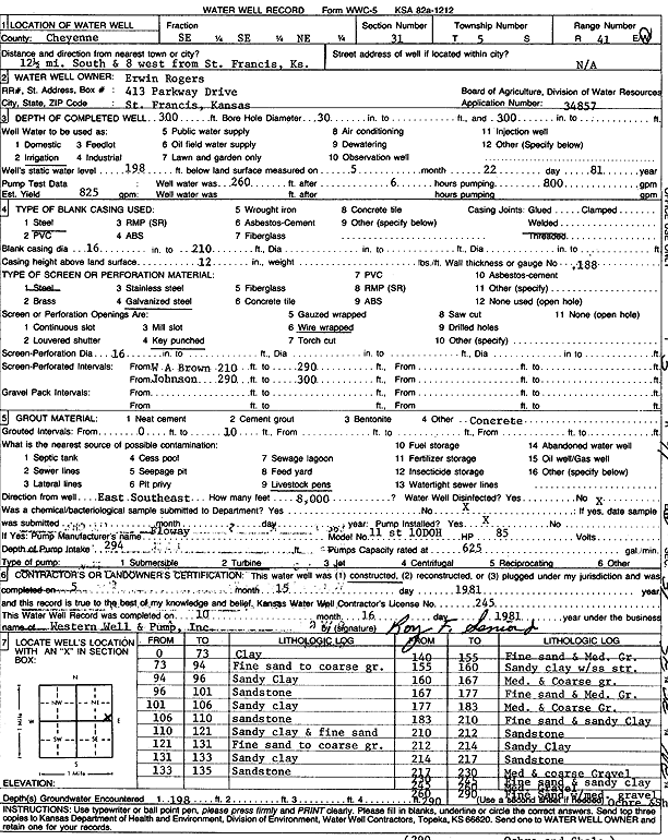
Specific Water Well Detail |
|
|
| Location Info | |||
| Owner: Rogers, Erwin | Status: Constructed | ||
| Location: T5S, R41W, Sec. 31, SE SE NE | County: Cheyenne | ||
| Directions: from St. Francis, 12.5 mi S and 8 mi W | |||
| Latitude: 39.5764904 | Longitude: -101.9573348 | Datum NAD 27 | |
| Latitude: 39.5764852 | Longitude: -101.9577933 | Datum NAD 83 | |
| Longitude and latitude calculated by Survey from township-range-section-quarter calls. Only good to within the quarter call accuracy. | |||
| View well on interactive map | |||
| General Info | ||
| Well Depth: 300 ft. | Elevation: ft. | |
| Static Water Level: 198 ft. | Est. Yield: 825 gpm. | |
| Comp. Date: 15-May-1981 | Well Use: Irrigation | |
| DWR Applic. #: 34857 | Other ID: | |
| Links | |
| No Wizard information available. | |
| View info from WIMAS Water Right Data base... | |
| Driller Info | ||
| Driller: Western Well & Pump, Inc. | License #: 245 | |
| Scanned Form | View scan |
|
Chemical Sample Submitted?:
Water Well disinfected?: | ||
| Casing Info | ||
| Casing Type:
Casing Joints: |
Diam: in. to ft | |
| Casing height above land surface: in
Casing Weight: lbs/ft Wall thickness or gauge no.: | ||
| Screen and Perforation Info | ||
| Screen Type: | Screen Openings: | |
| Screen-perforated intervals | From: ft to ft | |
| Gravel pack intervals | From: ft to ft | |
| Grout Info | ||
| Grout used: | From: to ft | |
| Source of Possible Contamination | ||
| Source: | ||
| Direction from well: | Distance: ft | |
| Lithologic Log
(Log data entered by KGS.) | ||
| From: 0 ft. to 73 ft. | Clay | |
| From: 73 ft. to 94 ft. | Fine sand to coarse gravel | |
| From: 94 ft. to 96 ft. | Sandy clay | |
| From: 96 ft. to 101 ft. | Sandstone | |
| From: 101 ft. to 106 ft. | Sandy clay | |
| From: 106 ft. to 110 ft. | Sandstone | |
| From: 110 ft. to 121 ft. | Sandy clay and fine sand | |
| From: 121 ft. to 131 ft. | Fine sand to coarse gravel | |
| From: 131 ft. to 133 ft. | Sandy clay | |
| From: 133 ft. to 135 ft. | Sandstone | |
| From: 140 ft. to 155 ft. | Fine sand and medium gravel | |
| From: 155 ft. to 160 ft. | Sandy clay with sandstone streaks | |
| From: 160 ft. to 167 ft. | Medium and coarse gravel | |
| From: 167 ft. to 177 ft. | Fine sand and medium gravel | |
| From: 177 ft. to 183 ft. | Medium and coarse gravel | |
| From: 183 ft. to 210 ft. | Fine sand and sandy clay | |
| From: 212 ft. to 212 ft. | Sandstone | |
| From: 212 ft. to 214 ft. | Sandy clay | |
| From: 214 ft. to 217 ft. | Sandstone | |
| From: 217 ft. to 230 ft. | Medium and coarse gravel | |
| From: 230 ft. to 245 ft. | Fine sand and sandy clay | |
| From: 245 ft. to 260 ft. | Medium gravel | |
| From: 260 ft. to 290 ft. | Fine sand with medium gravel | |
| From: 290 ft. to ft. | Ochre and shale | |