|
|
|
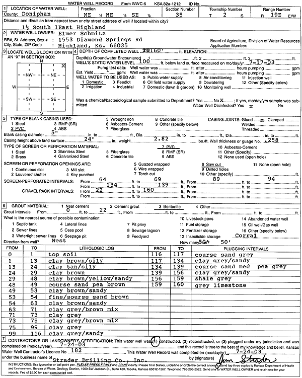
Specific Water Well Detail |
|
|
| Location Info | |||
| Owner: Schmitz, Elmer | Status: Constructed | ||
| Location: T2S, R19E, Sec. 35, NE NE SE | County: Doniphan | ||
| Directions: from Highland: 1.5 mi S, 1 mi E | |||
| Latitude: 39.8339398 | Longitude: -95.2473601 | Datum NAD 27 | |
| Latitude: 39.8339381 | Longitude: -95.2476135 | Datum NAD 83 | |
| Longitude and latitude calculated by Survey from township-range-section-quarter calls. Only good to within the quarter call accuracy. | |||
| View well on interactive map | |||
| General Info | ||
| Well Depth: 160 ft. | Elevation: ft. | |
| Static Water Level: 100 ft. | Est. Yield: 1 gpm. | |
| Comp. Date: 24-Jul-2003 | Well Use: Domestic | |
| DWR Applic. #: | Other ID: | |
| Driller Info | ||
| Driller: Strader Drilling Co., Inc. | License #: 182 | |
| Scanned Form | View scan |
|
Chemical Sample Submitted?:
Water Well disinfected?: | ||
| Casing Info | ||
| Casing Type:
Casing Joints: |
Diam: in. to ft | |
| Casing height above land surface: in
Casing Weight: lbs/ft Wall thickness or gauge no.: | ||
| Screen and Perforation Info | ||
| Screen Type: | Screen Openings: | |
| Screen-perforated intervals | From: ft to ft | |
| Gravel pack intervals | From: ft to ft | |
| Grout Info | ||
| Grout used: | From: to ft | |
| Source of Possible Contamination | ||
| Source: | ||
| Direction from well: | Distance: ft | |
| Lithologic Log
(Log data entered by KGS.) | ||
| From: 0 ft. to 1 ft. | Top soil | |
| From: 1 ft. to 13 ft. | Clay, brown, silty | |
| From: 13 ft. to 24 ft. | Clay, tan, silty | |
| From: 24 ft. to 29 ft. | Clay, brown | |
| From: 29 ft. to 48 ft. | Clay, brown, yellow, sandy | |
| From: 48 ft. to 49 ft. | Coarse sand, pea, brown | |
| From: 49 ft. to 53 ft. | Clay, brown, sandy | |
| From: 53 ft. to 54 ft. | Fine-coarse sand, brown | |
| From: 54 ft. to 63 ft. | Clay, brown, sandy | |
| From: 63 ft. to 71 ft. | Clay, gray-brown mix | |
| From: 71 ft. to 73 ft. | Clay, gray | |
| From: 73 ft. to 75 ft. | Clay, gray-brown mix | |
| From: 75 ft. to 99 ft. | Clay, gray | |
| From: 99 ft. to 116 ft. | Clay, gray, sandy | |
| From: 116 ft. to 117 ft. | Coarse sand, gray | |
| From: 117 ft. to 134 ft. | Clay, gray, sandy | |
| From: 134 ft. to 139 ft. | Coarse sand, medium-pea, gray | |
| From: 139 ft. to 156 ft. | Clay, gray, sandy | |
| From: 156 ft. to 159 ft. | Shale, gray | |
| From: 159 ft. to 160 ft. | Limestone, gray | |