|
|
|
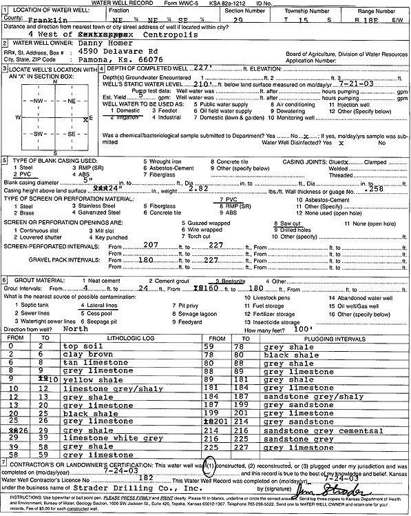
Specific Water Well Detail |
|
|
| Location Info | |||
| Owner: Homer, Danny | Status: Constructed | ||
| Location: T15S, R18E, Sec. 29, NE NE SE | County: Franklin | ||
| Directions: from Centropolis: 4 mi W | |||
| Latitude: 38.7160593 | Longitude: -95.4279033 | Datum NAD 27 | |
| Latitude: 38.7160666 | Longitude: -95.428159 | Datum NAD 83 | |
| Longitude and latitude calculated by Survey from township-range-section-quarter calls. Only good to within the quarter call accuracy. | |||
| View well on interactive map | |||
| General Info | ||
| Well Depth: 227 ft. | Elevation: ft. | |
| Static Water Level: 210 ft. | Est. Yield: 5 gpm. | |
| Comp. Date: 24-Jul-2003 | Well Use: Domestic | |
| DWR Applic. #: | Other ID: | |
| Driller Info | ||
| Driller: Strader Drilling Co., Inc. | License #: 182 | |
| Scanned Form | View scan |
|
Chemical Sample Submitted?:
Water Well disinfected?: | ||
| Casing Info | ||
| Casing Type:
Casing Joints: |
Diam: in. to ft | |
| Casing height above land surface: in
Casing Weight: lbs/ft Wall thickness or gauge no.: | ||
| Screen and Perforation Info | ||
| Screen Type: | Screen Openings: | |
| Screen-perforated intervals | From: ft to ft | |
| Gravel pack intervals | From: ft to ft | |
| Grout Info | ||
| Grout used: | From: to ft | |
| Source of Possible Contamination | ||
| Source: | ||
| Direction from well: | Distance: ft | |
| Lithologic Log
(Log data entered by KGS.) | ||
| From: 0 ft. to 2 ft. | Topsoil | |
| From: 2 ft. to 6 ft. | Clay, brown | |
| From: 6 ft. to 8 ft. | Limestone, tan | |
| From: 8 ft. to 9 ft. | Limestone, gray | |
| From: 9 ft. to 10 ft. | Shale, yellow | |
| From: 10 ft. to 12 ft. | Limestone, gray, shaley | |
| From: 12 ft. to 13 ft. | Shale, gray | |
| From: 13 ft. to 20 ft. | Limestone, gray | |
| From: 20 ft. to 25 ft. | Shale, black | |
| From: 25 ft. to 26 ft. | Limestone, gray | |
| From: 26 ft. to 29 ft. | Shale, gray | |
| From: 29 ft. to 39 ft. | Limestone, white gray | |
| From: 39 ft. to 58 ft. | Shale, gray | |
| From: 58 ft. to 59 ft. | Limestone, gray | |
| From: 59 ft. to 78 ft. | Shale, gray | |
| From: 78 ft. to 80 ft. | Shale, black | |
| From: 80 ft. to 88 ft. | Shale, gray | |
| From: 88 ft. to 89 ft. | Limestone, gray | |
| From: 89 ft. to 181 ft. | Shale, gray | |
| From: 181 ft. to 184 ft. | Limestone, gray | |
| From: 184 ft. to 187 ft. | Sandstone, gray, shaley | |
| From: 187 ft. to 199 ft. | Sandstone, gray | |
| From: 199 ft. to 201 ft. | Limestone, gray | |
| From: 201 ft. to 214 ft. | Sandstone, gray | |
| From: 214 ft. to 216 ft. | Cemented sandstone, gray | |
| From: 216 ft. to 225 ft. | Sandstone, gray | |
| From: 225 ft. to 227 ft. | Limestone, gray | |