|
|
|
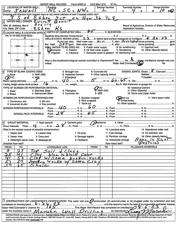
Specific Water Well Detail |
|
|
| Location Info | |||
| Owner: Benoit, Everett | Status: Constructed | ||
| Location: T4S, R10W, Sec. 2, NE SE NW | County: Jewell | ||
| Directions: from Esbon Jct: 3 mi S on Hwy 36, .5 mi E | |||
| Latitude: 39.7368686 | Longitude: -98.4212617 | Datum NAD 27 | |
| Latitude: 39.7368802 | Longitude: -98.4215992 | Datum NAD 83 | |
| Longitude and latitude calculated by Survey from township-range-section-quarter calls. Only good to within the quarter call accuracy. | |||
| View well on interactive map | |||
| General Info | ||
| Well Depth: 65 ft. | Elevation: ft. | |
| Static Water Level: 22 ft. | Est. Yield: 20 gpm. | |
| Comp. Date: 26-Jun-2003 | Well Use: Domestic | |
| DWR Applic. #: | Other ID: | |
| Driller Info | ||
| Driller: Leroy Maruhn Well Drilling, Inc. | License #: 165 | |
| Scanned Form | View scan |
|
Chemical Sample Submitted?:
Water Well disinfected?: | ||
| Casing Info | ||
| Casing Type:
Casing Joints: |
Diam: in. to ft | |
| Casing height above land surface: in
Casing Weight: lbs/ft Wall thickness or gauge no.: | ||
| Screen and Perforation Info | ||
| Screen Type: | Screen Openings: | |
| Screen-perforated intervals | From: ft to ft | |
| Gravel pack intervals | From: ft to ft | |
| Grout Info | ||
| Grout used: | From: to ft | |
| Source of Possible Contamination | ||
| Source: | ||
| Direction from well: | Distance: ft | |
| Lithologic Log
(Log data entered by KGS.) | ||
| From: 0 ft. to 25 ft. | top soil and clays | |
| From: 25 ft. to 41 ft. | clay, blue to black color | |
| From: 41 ft. to 52 ft. | clay with some broken rocks | |
| From: 52 ft. to 57 ft. | broken rocks with some clay | |
| From: 57 ft. to 65 ft. | shale | |