|
|
|
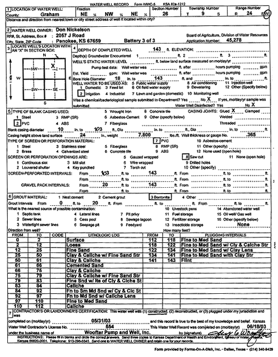
Specific Water Well Detail |
|
|
| Location Info | |||
| Owner: Nickelson, Don | Status: Constructed | ||
| Location: T9S, R24W, Sec. 26, NE NW NE | County: Graham | ||
| Directions: | |||
| Latitude: 39.2470786 | Longitude: -99.9643544 | Datum NAD 27 | |
| Latitude: 39.2470839 | Longitude: -99.9647575 | Datum NAD 83 | |
| Longitude and latitude calculated by Survey from township-range-section-quarter calls. Only good to within the quarter call accuracy. | |||
| View well on interactive map | |||
| General Info | ||
| Well Depth: 143 ft. | Elevation: ft. | |
| Static Water Level: ft. | Est. Yield: gpm. | |
| Comp. Date: 31-May-2003 | Well Use: Irrigation | |
| DWR Applic. #: 45278 | Other ID: Battery 3 of 3 | |
| Links | |
| No Wizard information available. | |
| View info from WIMAS Water Right Data base... | |
| Driller Info | ||
| Driller: Jay C. Woofter Pump & Well, Inc. | License #: 554 | |
| Scanned Form | View scan |
|
Chemical Sample Submitted?:
Water Well disinfected?: | ||
| Casing Info | ||
| Casing Type:
Casing Joints: |
Diam: in. to ft | |
| Casing height above land surface: in
Casing Weight: lbs/ft Wall thickness or gauge no.: | ||
| Screen and Perforation Info | ||
| Screen Type: | Screen Openings: | |
| Screen-perforated intervals | From: ft to ft | |
| Gravel pack intervals | From: ft to ft | |
| Grout Info | ||
| Grout used: | From: to ft | |
| Source of Possible Contamination | ||
| Source: | ||
| Direction from well: | Distance: ft | |
| Lithologic Log
(Log data entered by KGS.) | ||
| From: 0 ft. to 2 ft. | surface | |
| From: 2 ft. to 12 ft. | loess | |
| From: 12 ft. to 25 ft. | fine sand | |
| From: 25 ft. to 50 ft. | clay and caliche with fine sand streak | |
| From: 50 ft. to 61 ft. | clay and caliche | |
| From: 61 ft. to 66 ft. | cemented sand | |
| From: 66 ft. to 75 ft. | clay and caliche | |
| From: 75 ft. to 79 ft. | clay and caliche with fine sand streak | |
| From: 79 ft. to 83 ft. | fine sand with lots of clay and caliche streak | |
| From: 83 ft. to 84 ft. | caliche | |
| From: 84 ft. to 92 ft. | fine to small medium sand with clay and caliche streak | |
| From: 92 ft. to 97 ft. | fine to medium sand with caliche lens | |
| From: 97 ft. to 110 ft. | fine to medium sand | |
| From: 110 ft. to 112 ft. | caliche | |
| From: 112 ft. to 118 ft. | fine to medium sand | |
| From: 118 ft. to 122 ft. | fine to medium sand with clay and caliche streak | |
| From: 122 ft. to 134 ft. | fine to medium sand with clay lens | |
| From: 134 ft. to 141 ft. | fine to medium sand with clay streak | |
| From: 141 ft. to 143 ft. | flint | |