|
|
|
Specific Water Well Detail |
|
|
| Location Info | |||
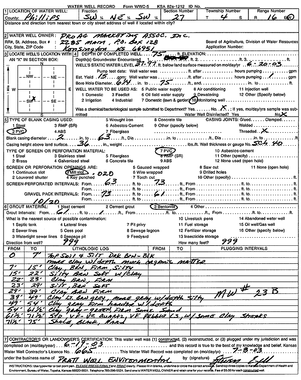
| Owner: Pro Ag Marketing Association, Inc | Status: Constructed | ||
| Location: T4S, R16W, Sec. 27, SW NE SW | County: Phillips | ||
| Directions: | |||
| Latitude: 39.6739256 | Longitude: -99.1161431 | Datum NAD 27 | |
| Latitude: 39.6739363 | Longitude: -99.1165093 | Datum NAD 83 | |
| Longitude and latitude calculated by Survey from township-range-section-quarter calls. Only good to within the quarter call accuracy. | |||
| View well on interactive map | |||
| General Info | ||
| Well Depth: 75 ft. | Elevation: ft. | |
| Static Water Level: 37.97 ft. | Est. Yield: 15 gpm. | |
| Comp. Date: 19-Jun-2003 | Well Use: Monitoring well/observation/piezometer | |
| DWR Applic. #: | Other ID: MW 23B | |
| Driller Info | ||
| Driller: Pratt Well Service, Inc. | License #: 665 | |
| Scanned Form | View scan |
|
Chemical Sample Submitted?:
Water Well disinfected?: | ||
| Casing Info | ||
| Casing Type:
Casing Joints: |
Diam: in. to ft | |
| Casing height above land surface: in
Casing Weight: lbs/ft Wall thickness or gauge no.: | ||
| Screen and Perforation Info | ||
| Screen Type: | Screen Openings: | |
| Screen-perforated intervals | From: ft to ft | |
| Gravel pack intervals | From: ft to ft | |
| Grout Info | ||
| Grout used: | From: to ft | |
| Source of Possible Contamination | ||
| Source: | ||
| Direction from well: | Distance: ft | |
| Lithologic Log
(Log data entered by KGS.) | ||
| From: 0 ft. to 7 ft. | top soil and silt, dark brown-black, more clay with depth, much organic matter | |
| From: 7 ft. to 15 ft. | clay, brown, firm, silty | |
| From: 15 ft. to 22 ft. | silty brown soft with clay | |
| From: 22 ft. to 23 ft. | clay brown firm | |
| From: 23 ft. to 29 ft. | silt brown soft | |
| From: 29 ft. to 39 ft. | clay brown firm | |
| From: 39 ft. to 49 ft. | clay light brown gray, more gray with depth, silty | |
| From: 49 ft. to 54 ft. | clay, gray, firm, harder with depth | |
| From: 54 ft. to 61.5 ft. | clay, gray-green, firm, some sand | |
| From: 61.5 ft. to 71.5 ft. | sand, very fine-very coarse, quartz, very fine pebbles, limestone, with some clay streaks | |
| From: 71.5 ft. to 75 ft. | shale, black, hard | |