|
|
|
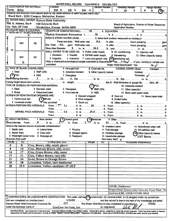
Specific Water Well Detail |
|
|
| Location Info | |||
| Owner: Kansas State University | Status: Constructed | ||
| Location: T10S, R8E, Sec. 7, SW SE SW | County: Riley | ||
| Directions: Ward Hall, KSU campus, Manhattan (Project No. U5 081 10113) | |||
| Latitude: 39.1904997 | Longitude: -96.5787207 | Datum NAD 27 | |
| Latitude: 39.1904967 | Longitude: -96.5790014 | Datum NAD 83 | |
| Longitude and latitude calculated by Survey from township-range-section-quarter calls. Only good to within the quarter call accuracy. | |||
| View well on interactive map | |||
| General Info | ||
| Well Depth: 39 ft. | Elevation: ft. | |
| Static Water Level: ft. | Est. Yield: gpm. | |
| Comp. Date: 22-Jan-2001 | Well Use: Monitoring well/observation/piezometer | |
| DWR Applic. #: | Other ID: MW 1 R | |
| Driller Info | ||
| Driller: GeoCore Services Inc. | License #: 527 | |
| Scanned Form | View scan |
|
Chemical Sample Submitted?:
Water Well disinfected?: | ||
| Casing Info | ||
| Casing Type:
Casing Joints: |
Diam: in. to ft | |
| Casing height above land surface: in
Casing Weight: lbs/ft Wall thickness or gauge no.: | ||
| Screen and Perforation Info | ||
| Screen Type: | Screen Openings: | |
| Screen-perforated intervals | From: ft to ft | |
| Gravel pack intervals | From: ft to ft | |
| Grout Info | ||
| Grout used: | From: to ft | |
| Source of Possible Contamination | ||
| Source: | ||
| Direction from well: | Distance: ft | |
| Lithologic Log
(Log data entered by KGS.) | ||
| From: 0 ft. to 8 ft. | silty clay, brown, moist, plastic | |
| From: 8 ft. to 14 ft. | silty clay, medium brown, moist | |
| From: 14 ft. to 17 ft. | silty clay, green brown, moist | |
| From: 17 ft. to 21 ft. | clay, very silty, yellow brown | |
| From: 21 ft. to 34 ft. | sand, brown to orange brown | |
| From: 34 ft. to 38 ft. | limestone, very weathered, yellow | |
| From: 38 ft. to 39.5 ft. | limestone, yellow, consistent at 39-29.5 feet | |