|
|
|
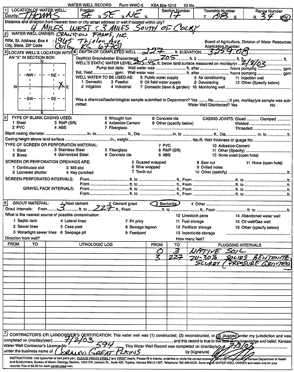
Specific Water Well Detail |
|
|
| Location Info | |||
| Owner: Cranston Farms, Inc. | Status: Plugged | ||
| Location: T8S, R34W, Sec. 17, SE SE NE | County: Thomas | ||
| Directions: from Colby: 3 mi W, 3 mi S | |||
| Latitude: 39.3594221 | Longitude: -101.130826 | Datum NAD 27 | |
| Latitude: 39.3594257 | Longitude: -101.1312607 | Datum NAD 83 | |
| Longitude and latitude calculated by Survey from township-range-section-quarter calls. Only good to within the quarter call accuracy. | |||
| View well on interactive map | |||
| General Info | ||
| Well Depth: 227 ft. | Elevation: 3259.08 ft. | |
| Static Water Level: 205.45 ft. | Est. Yield: gpm. | |
| Comp. Date: 02-Jul-2003 | Well Use: (unstated)/abandoned | |
| DWR Applic. #: | Other ID: MW 5 | |
| Driller Info | ||
| Driller: Coranco Great Plains, Inc. | License #: 594 | |
| Scanned Form | View scan |
| Casing Info | ||
|
Casing Type:
Diam: in. Casing height above land surface: in | ||
| Grout Info | ||
| Grout used: | From: to ft | |
| Source of Possible Contamination | ||
| Source: | ||
| Direction from well: | Distance: ft | |