|
|
|
Specific Water Well Detail |
|
|
| Location Info | |||
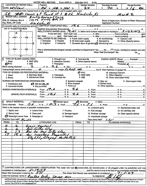
| Owner: Bentley Garment Care | Status: Constructed | ||
| Location: T30S, R16E, Sec. 20, NW NE NW | County: Wilson | ||
| Directions: SE corner of Tank St and 8th, Neodesha | |||
| Latitude: 37.427403 | Longitude: -95.6823689 | Datum NAD 27 | |
| Latitude: 37.4274622 | Longitude: -95.6826271 | Datum NAD 83 | |
| Longitude and latitude calculated by Survey from township-range-section-quarter calls. Only good to within the quarter call accuracy. | |||
| View well on interactive map | |||
| General Info | ||
| Well Depth: 19.6 ft. | Elevation: ft. | |
| Static Water Level: 9.01 ft. | Est. Yield: gpm. | |
| Comp. Date: 19-May-2003 | Well Use: Monitoring well/observation/piezometer | |
| DWR Applic. #: | Other ID: MW 2 | |
| Driller Info | ||
| Driller: Funkee Drilling Service | License #: 575 | |
| Scanned Form | View scan |
|
Chemical Sample Submitted?:
Water Well disinfected?: | ||
| Casing Info | ||
| Casing Type:
Casing Joints: |
Diam: in. to ft | |
| Casing height above land surface: in
Casing Weight: lbs/ft Wall thickness or gauge no.: | ||
| Screen and Perforation Info | ||
| Screen Type: | Screen Openings: | |
| Screen-perforated intervals | From: ft to ft | |
| Gravel pack intervals | From: ft to ft | |
| Grout Info | ||
| Grout used: | From: to ft | |
| Source of Possible Contamination | ||
| Source: | ||
| Direction from well: | Distance: ft | |
| Lithologic Log
(Log data entered by KGS.) | ||
| From: 0 ft. to 2 ft. | grass and top soil | |
| From: 2 ft. to 6 ft. | brown silty clay | |
| From: 6 ft. to 13 ft. | brown to tan silty clay | |
| From: 13 ft. to 19.6 ft. | tan limestone fragments, slightly clayey, hard at 19.6 feet | |