|
|
|
Specific Water Well Detail |
|
|
| Location Info | |||
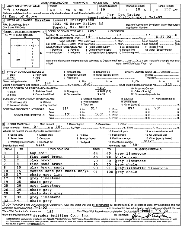
| Owner: Russell Enterprises | Status: Constructed | ||
| Location: T10S, R15E, Sec. 19, NE NE NE | County: Shawnee | ||
| Directions: from Grove: 4.5 mi E | |||
| Latitude: 39.1722343 | Longitude: -95.776223 | Datum NAD 27 | |
| Latitude: 39.1722325 | Longitude: -95.7764852 | Datum NAD 83 | |
| Longitude and latitude calculated by Survey from township-range-section-quarter calls. Only good to within the quarter call accuracy. | |||
| View well on interactive map | |||
| General Info | ||
| Well Depth: 100 ft. | Elevation: ft. | |
| Static Water Level: 10 ft. | Est. Yield: .5 gpm. | |
| Comp. Date: 09-Jul-2003 | Well Use: Domestic | |
| DWR Applic. #: | Other ID: | |
| Driller Info | ||
| Driller: Strader Drilling Co., Inc. | License #: 182 | |
| Scanned Form | View scan |
|
Chemical Sample Submitted?:
Water Well disinfected?: | ||
| Casing Info | ||
| Casing Type:
Casing Joints: |
Diam: in. to ft | |
| Casing height above land surface: in
Casing Weight: lbs/ft Wall thickness or gauge no.: | ||
| Screen and Perforation Info | ||
| Screen Type: | Screen Openings: | |
| Screen-perforated intervals | From: ft to ft | |
| Gravel pack intervals | From: ft to ft | |
| Grout Info | ||
| Grout used: | From: to ft | |
| Source of Possible Contamination | ||
| Source: | ||
| Direction from well: | Distance: ft | |
| Lithologic Log
(Log data entered by KGS.) | ||
| From: 0 ft. to 1 ft. | top soil | |
| From: 1 ft. to 3 ft. | fine sand, brown | |
| From: 3 ft. to 7 ft. | clay, brown | |
| From: 7 ft. to 8 ft. | fine sand, brown | |
| From: 8 ft. to 10 ft. | sandy clay, brown | |
| From: 10 ft. to 15 ft. | coarse sand, pea chert, brown-yellow | |
| From: 15 ft. to 17 ft. | shale, gray, limy | |
| From: 17 ft. to 19 ft. | limestone, gray | |
| From: 19 ft. to 25 ft. | shale, gray | |
| From: 25 ft. to 26 ft. | limestone, gray | |
| From: 26 ft. to 29 ft. | shale, gray | |
| From: 29 ft. to 31 ft. | shale, dark gray | |
| From: 31 ft. to 33 ft. | limestone, gray | |
| From: 33 ft. to 44 ft. | shale, gray | |
| From: 44 ft. to 45 ft. | limestone, gray | |
| From: 45 ft. to 79 ft. | shale, gray | |
| From: 79 ft. to 80 ft. | limestone, gray | |
| From: 80 ft. to 90 ft. | shale, gray | |
| From: 90 ft. to 91 ft. | limestone, gray | |
| From: 91 ft. to 100 ft. | shale, gray | |