|
|
|
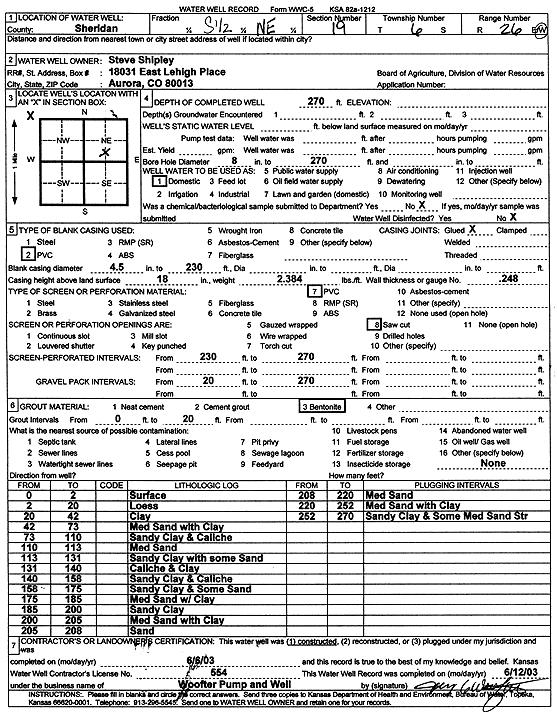
Specific Water Well Detail |
|
|
| Location Info | |||
| Owner: Shipley, Steve | Status: Constructed | ||
| Location: T6S, R26W, Sec. 19, S2 NE | County: Sheridan | ||
| Directions: | |||
| Latitude: 39.5180771 | Longitude: -100.2599365 | Datum NAD 27 | |
| Latitude: 39.5180804 | Longitude: -100.2603519 | Datum NAD 83 | |
| Longitude and latitude calculated by Survey from township-range-section-quarter calls. Only good to within the quarter call accuracy. | |||
| View well on interactive map | |||
| General Info | ||
| Well Depth: 270 ft. | Elevation: ft. | |
| Static Water Level: ft. | Est. Yield: gpm. | |
| Comp. Date: 06-Jun-2003 | Well Use: Domestic | |
| DWR Applic. #: | Other ID: | |
| Driller Info | ||
| Driller: Woofter Pump & Well, Inc. | License #: 554 | |
| Scanned Form | View scan |
|
Chemical Sample Submitted?:
Water Well disinfected?: | ||
| Casing Info | ||
| Casing Type:
Casing Joints: |
Diam: in. to ft | |
| Casing height above land surface: in
Casing Weight: lbs/ft Wall thickness or gauge no.: | ||
| Screen and Perforation Info | ||
| Screen Type: | Screen Openings: | |
| Screen-perforated intervals | From: ft to ft | |
| Gravel pack intervals | From: ft to ft | |
| Grout Info | ||
| Grout used: | From: to ft | |
| Source of Possible Contamination | ||
| Source: | ||
| Direction from well: | Distance: ft | |
| Lithologic Log
(Log data entered by KGS.) | ||
| From: 0 ft. to 2 ft. | Surface | |
| From: 2 ft. to 20 ft. | Loess | |
| From: 20 ft. to 42 ft. | Clay | |
| From: 42 ft. to 73 ft. | Medium sand with clay | |
| From: 73 ft. to 110 ft. | Sandy clay and caliche | |
| From: 110 ft. to 113 ft. | Medium sand | |
| From: 113 ft. to 131 ft. | Sandy clay with some sand | |
| From: 131 ft. to 140 ft. | Caliche and clay | |
| From: 140 ft. to 158 ft. | Sandy clay and caliche | |
| From: 158 ft. to 175 ft. | Sandy clay and some sand | |
| From: 175 ft. to 185 ft. | Medium sand with clay | |
| From: 185 ft. to 200 ft. | Sandy clay | |
| From: 200 ft. to 205 ft. | Medium sand with clay | |
| From: 205 ft. to 208 ft. | Sand | |
| From: 208 ft. to 220 ft. | Medium sand | |
| From: 220 ft. to 252 ft. | Medium sand with clay | |
| From: 252 ft. to 270 ft. | Sandy clay and some medium sand streaks | |