|
|
|
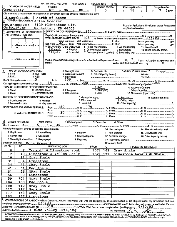
Specific Water Well Detail |
|
|
| Location Info | |||
| Owner: Loecker, Arlen | Status: Constructed | ||
| Location: T10S, R7E, Sec. 5, NE SW NW | County: Riley | ||
| Directions: from Keats: 2 mi SE, .25 mi N | |||
| Latitude: 39.2136606 | Longitude: -96.6782523 | Datum NAD 27 | |
| Latitude: 39.213657 | Longitude: -96.6785357 | Datum NAD 83 | |
| Longitude and latitude calculated by Survey from township-range-section-quarter calls. Only good to within the quarter call accuracy. | |||
| View well on interactive map | |||
| General Info | ||
| Well Depth: 170 ft. | Elevation: ft. | |
| Static Water Level: 108 ft. | Est. Yield: 40 gpm. | |
| Comp. Date: 05-Aug-2003 | Well Use: Domestic | |
| DWR Applic. #: | Other ID: | |
| Driller Info | ||
| Driller: Blue Valley Drilling | License #: 518 | |
| Scanned Form | View scan |
|
Chemical Sample Submitted?:
Water Well disinfected?: | ||
| Casing Info | ||
| Casing Type:
Casing Joints: |
Diam: in. to ft | |
| Casing height above land surface: in
Casing Weight: lbs/ft Wall thickness or gauge no.: | ||
| Screen and Perforation Info | ||
| Screen Type: | Screen Openings: | |
| Screen-perforated intervals | From: ft to ft | |
| Gravel pack intervals | From: ft to ft | |
| Grout Info | ||
| Grout used: | From: to ft | |
| Source of Possible Contamination | ||
| Source: | ||
| Direction from well: | Distance: ft | |
| Lithologic Log
(Log data entered by KGS.) | ||
| From: 0 ft. to 2 ft. | top soil and limestone rock | |
| From: 2 ft. to 19 ft. | limestone and yellow shale | |
| From: 19 ft. to 31 ft. | gray shale | |
| From: 31 ft. to 34 ft. | limestone | |
| From: 34 ft. to 41 ft. | gray shale | |
| From: 41 ft. to 51 ft. | red shale | |
| From: 51 ft. to 56 ft. | gray shale | |
| From: 56 ft. to 59 ft. | limestone | |
| From: 59 ft. to 104 ft. | gray shale | |
| From: 104 ft. to 108 ft. | red shale | |
| From: 108 ft. to 112 ft. | gray shale | |
| From: 112 ft. to 117 ft. | gypsum | |
| From: 117 ft. to 153 ft. | gray shale | |
| From: 153 ft. to 157 ft. | limestone | |
| From: 157 ft. to 162 ft. | gray shale | |
| From: 162 ft. to 171 ft. | limestone layers and shale | |