|
|
|
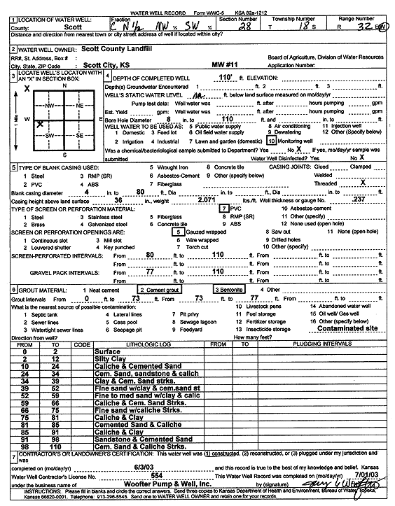
Specific Water Well Detail |
|
|
| Location Info | |||
| Owner: Scott County Landfill | Status: Constructed | ||
| Location: T18S, R32W, Sec. 28, C N2 NW SW | County: Scott | ||
| Directions: | |||
| Latitude: 38.4599495 | Longitude: -100.8672213 | Datum NAD 27 | |
| Latitude: 38.4599687 | Longitude: -100.8676495 | Datum NAD 83 | |
| Longitude and latitude calculated by Survey from township-range-section-quarter calls. Only good to within the quarter call accuracy. | |||
| View well on interactive map | |||
| General Info | ||
| Well Depth: 110 ft. | Elevation: ft. | |
| Static Water Level: ft. | Est. Yield: gpm. | |
| Comp. Date: 03-Jun-2003 | Well Use: Monitoring well/observation/piezometer | |
| DWR Applic. #: | Other ID: MW 11 | |
| Driller Info | ||
| Driller: Jay C. Woofter Pump & Well, Inc. | License #: 554 | |
| Scanned Form | View scan |
|
Chemical Sample Submitted?:
Water Well disinfected?: | ||
| Casing Info | ||
| Casing Type:
Casing Joints: |
Diam: in. to ft | |
| Casing height above land surface: in
Casing Weight: lbs/ft Wall thickness or gauge no.: | ||
| Screen and Perforation Info | ||
| Screen Type: | Screen Openings: | |
| Screen-perforated intervals | From: ft to ft | |
| Gravel pack intervals | From: ft to ft | |
| Grout Info | ||
| Grout used: | From: to ft | |
| Source of Possible Contamination | ||
| Source: | ||
| Direction from well: | Distance: ft | |
| Lithologic Log
(Log data entered by KGS.) | ||
| From: 0 ft. to 2 ft. | surface | |
| From: 2 ft. to 10 ft. | silty clay | |
| From: 10 ft. to 24 ft. | caliche and cemented sand | |
| From: 24 ft. to 34 ft. | cemented sand, sandstone and caliche | |
| From: 34 ft. to 39 ft. | clay and cemented sand streaks | |
| From: 39 ft. to 52 ft. | fine sand with clay and cemented sand streaks | |
| From: 52 ft. to 59 ft. | fine to medium sand with clay and caliche | |
| From: 59 ft. to 66 ft. | caliche and cemented sand streaks | |
| From: 66 ft. to 75 ft. | fine sand with caliche streaks | |
| From: 75 ft. to 81 ft. | caliche and clay | |
| From: 81 ft. to 85 ft. | cemented sand and caliche | |
| From: 85 ft. to 91 ft. | caliche and clay | |
| From: 91 ft. to 98 ft. | sandstone and cemented sand | |
| From: 98 ft. to 110 ft. | cemented sand and caliche streaks | |