|
|
|
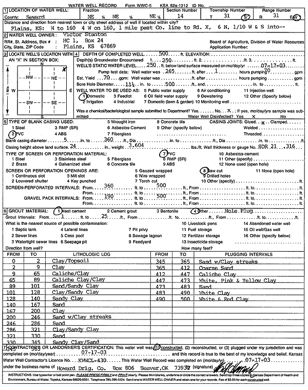
Specific Water Well Detail |
|
|
| Location Info | |||
| Owner: Stanton, Victor | Status: Constructed | ||
| Location: T31S, R31W, Sec. 14, NE NE NE | County: Seward | ||
| Directions: from Plains: N to 160, 4 mi W on 160, 1 mi past Co line to Rd X, 6 mi N, .1 W and S into | |||
| Latitude: 37.3576676 | Longitude: -100.6534001 | Datum NAD 27 | |
| Latitude: 37.3576898 | Longitude: -100.6538329 | Datum NAD 83 | |
| Longitude and latitude calculated by Survey from township-range-section-quarter calls. Only good to within the quarter call accuracy. | |||
| View well on interactive map | |||
| General Info | ||
| Well Depth: 500 ft. | Elevation: ft. | |
| Static Water Level: 250 ft. | Est. Yield: 70 gpm. | |
| Comp. Date: 17-Jul-2003 | Well Use: Domestic | |
| DWR Applic. #: | Other ID: | |
| Driller Info | ||
| Driller: Howard Drilling Company AG, LLC | License #: 430 | |
| Scanned Form | View scan |
|
Chemical Sample Submitted?:
Water Well disinfected?: | ||
| Casing Info | ||
| Casing Type:
Casing Joints: |
Diam: in. to ft | |
| Casing height above land surface: in
Casing Weight: lbs/ft Wall thickness or gauge no.: | ||
| Screen and Perforation Info | ||
| Screen Type: | Screen Openings: | |
| Screen-perforated intervals | From: ft to ft | |
| Gravel pack intervals | From: ft to ft | |
| Grout Info | ||
| Grout used: | From: to ft | |
| Source of Possible Contamination | ||
| Source: | ||
| Direction from well: | Distance: ft | |
| Lithologic Log
(Log data entered by KGS.) | ||
| From: 0 ft. to 2 ft. | clay/topsoil | |
| From: 2 ft. to 9 ft. | clay | |
| From: 9 ft. to 65 ft. | caliche/clay | |
| From: 65 ft. to 89 ft. | caliche clay/clay | |
| From: 89 ft. to 101 ft. | sand/sandy clay | |
| From: 101 ft. to 128 ft. | clay/sandy clay | |
| From: 128 ft. to 140 ft. | sandy clay | |
| From: 140 ft. to 167 ft. | sand | |
| From: 167 ft. to 200 ft. | clay | |
| From: 200 ft. to 246 ft. | sand with clay streaks | |
| From: 246 ft. to 286 ft. | sand | |
| From: 286 ft. to 321 ft. | clay/sandy clay | |
| From: 321 ft. to 330 ft. | sand | |
| From: 330 ft. to 345 ft. | sandy clay/sand | |
| From: 345 ft. to 365 ft. | sand with clay streaks | |
| From: 365 ft. to 412 ft. | coarse sand | |
| From: 412 ft. to 447 ft. | caliche clay | |
| From: 447 ft. to 473 ft. | white, pink and yellow clay | |
| From: 473 ft. to 483 ft. | sand | |
| From: 483 ft. to 490 ft. | white clay | |
| From: 490 ft. to 500 ft. | white and red clay | |