|
|
|
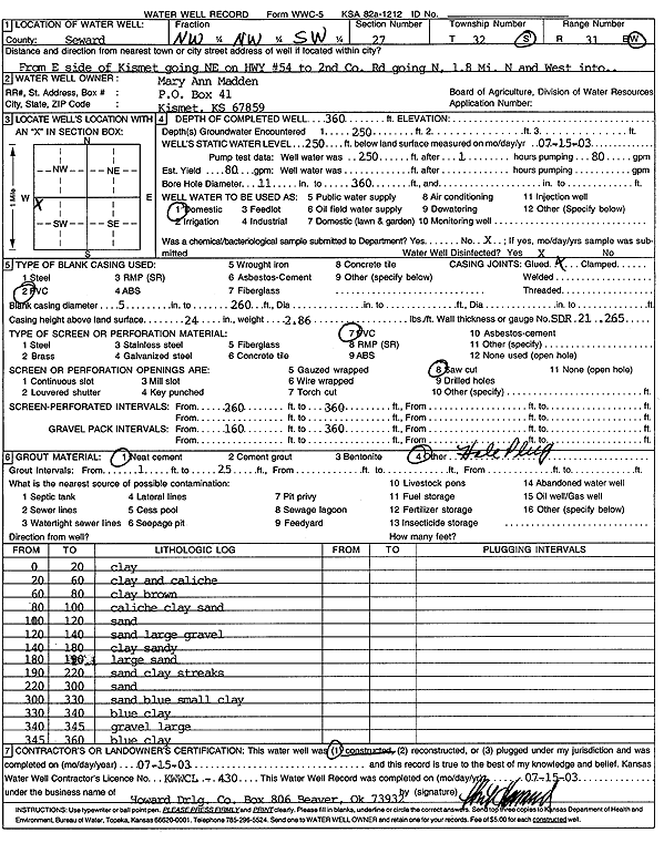
Specific Water Well Detail |
|
|
| Location Info | |||
| Owner: Mary Ann Madden | Status: Constructed | ||
| Location: T32S, R31W, Sec. 27, NW NW SW | County: Seward | ||
| Directions: from E side of Kismet: NE on Hwy 54 to 2nd Co Rd going N, 1.8 mi N and W into | |||
| Latitude: 37.2341576 | Longitude: -100.6883871 | Datum NAD 27 | |
| Latitude: 37.2341782 | Longitude: -100.68882 | Datum NAD 83 | |
| Longitude and latitude calculated by Survey from township-range-section-quarter calls. Only good to within the quarter call accuracy. | |||
| View well on interactive map | |||
| General Info | ||
| Well Depth: 360 ft. | Elevation: ft. | |
| Static Water Level: 250 ft. | Est. Yield: 80 gpm. | |
| Comp. Date: 15-Jul-2003 | Well Use: Domestic | |
| DWR Applic. #: | Other ID: | |
| Driller Info | ||
| Driller: Howard Drilling Company AG, LLC | License #: 430 | |
| Scanned Form | View scan |
|
Chemical Sample Submitted?:
Water Well disinfected?: | ||
| Casing Info | ||
| Casing Type:
Casing Joints: |
Diam: in. to ft | |
| Casing height above land surface: in
Casing Weight: lbs/ft Wall thickness or gauge no.: | ||
| Screen and Perforation Info | ||
| Screen Type: | Screen Openings: | |
| Screen-perforated intervals | From: ft to ft | |
| Gravel pack intervals | From: ft to ft | |
| Grout Info | ||
| Grout used: | From: to ft | |
| Source of Possible Contamination | ||
| Source: | ||
| Direction from well: | Distance: ft | |
| Lithologic Log
(Log data entered by KGS.) | ||
| From: 0 ft. to 20 ft. | clay | |
| From: 20 ft. to 60 ft. | clay and caliche | |
| From: 60 ft. to 80 ft. | clay brown | |
| From: 80 ft. to 100 ft. | caliche clay sand | |
| From: 100 ft. to 120 ft. | sand | |
| From: 120 ft. to 140 ft. | sand large gravel | |
| From: 140 ft. to 180 ft. | clay sandy | |
| From: 180 ft. to 190 ft. | large sand | |
| From: 190 ft. to 220 ft. | sand clay streaks | |
| From: 220 ft. to 300 ft. | sand | |
| From: 300 ft. to 330 ft. | sand blue small clay | |
| From: 330 ft. to 340 ft. | blue clay | |
| From: 340 ft. to 345 ft. | gravel large | |
| From: 345 ft. to 360 ft. | blue clay | |