|
|
|
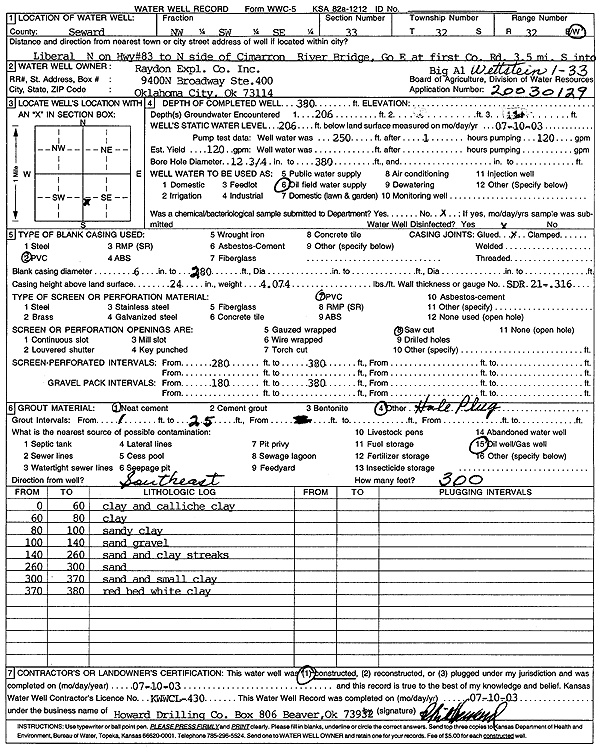
Specific Water Well Detail |
|
|
| Location Info | |||
| Owner: Raydon Exploration Co., Inc. | Status: Constructed | ||
| Location: T32S, R32W, Sec. 33, NW SW SE | County: Seward | ||
| Directions: from Liberal: N on Hwy 83 to N side of Cimarron River Bridge, Go E at 1st Co Rd, 3.5 mi S into | |||
| Latitude: 37.2163538 | Longitude: -100.8047 | Datum NAD 27 | |
| Latitude: 37.216375 | Longitude: -100.8051366 | Datum NAD 83 | |
| Longitude and latitude calculated by Survey from township-range-section-quarter calls. Only good to within the quarter call accuracy. | |||
| View well on interactive map | |||
| General Info | ||
| Well Depth: 380 ft. | Elevation: ft. | |
| Static Water Level: 206 ft. | Est. Yield: 120 gpm. | |
| Comp. Date: 10-Jul-2003 | Well Use: Oil Field Water Supply | |
| DWR Applic. #: 20030129 | Other ID: Wettstein 1-33 | |
| Links | |
| No Wizard information available. | |
| View info from WIMAS Water Right Data base... | |
| Driller Info | ||
| Driller: Howard Drilling Company AG, LLC | License #: 430 | |
| Scanned Form | View scan |
|
Chemical Sample Submitted?:
Water Well disinfected?: | ||
| Casing Info | ||
| Casing Type:
Casing Joints: |
Diam: in. to ft | |
| Casing height above land surface: in
Casing Weight: lbs/ft Wall thickness or gauge no.: | ||
| Screen and Perforation Info | ||
| Screen Type: | Screen Openings: | |
| Screen-perforated intervals | From: ft to ft | |
| Gravel pack intervals | From: ft to ft | |
| Grout Info | ||
| Grout used: | From: to ft | |
| Source of Possible Contamination | ||
| Source: | ||
| Direction from well: | Distance: ft | |
| Lithologic Log
(Log data entered by KGS.) | ||
| From: 0 ft. to 60 ft. | clay and caliche | |
| From: 60 ft. to 80 ft. | clay | |
| From: 80 ft. to 100 ft. | sandy clay | |
| From: 100 ft. to 140 ft. | sand gravel | |
| From: 140 ft. to 260 ft. | sand and clay streaks | |
| From: 260 ft. to 300 ft. | sand | |
| From: 300 ft. to 370 ft. | sand and small clay | |
| From: 370 ft. to 380 ft. | red bed white clay | |