|
|
|
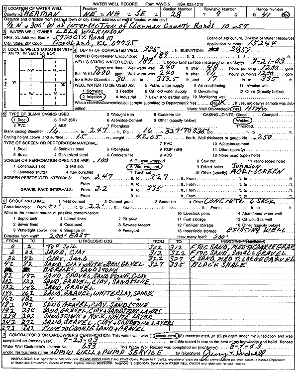
Specific Water Well Detail |
|
|
| Location Info | |||
| Owner: Wilkinson, Lela | Status: Constructed | ||
| Location: T9S, R41W, Sec. 28, NE NE SE | County: Sherman | ||
| Directions: from Sherman Co. Rd 10 and Rd 57: 0.5 mi N, 300 feet W | |||
| Latitude: 39.2410233 | Longitude: -101.8946406 | Datum NAD 27 | |
| Latitude: 39.2410246 | Longitude: -101.8950954 | Datum NAD 83 | |
| Longitude and latitude calculated by Survey from township-range-section-quarter calls. Only good to within the quarter call accuracy. | |||
| View well on interactive map | |||
| General Info | ||
| Well Depth: 335 ft. | Elevation: 3853 ft. | |
| Static Water Level: 189 ft. | Est. Yield: 1600 gpm. | |
| Comp. Date: 23-Jul-2003 | Well Use: Irrigation | |
| DWR Applic. #: 15244 | Other ID: | |
| Links | |
| No Wizard information available. | |
| View info from WIMAS Water Right Data base... | |
| Driller Info | ||
| Driller: DMW Well & Pump Srvc | License #: 633 | |
| Scanned Form | View scan |
|
Chemical Sample Submitted?:
Water Well disinfected?: | ||
| Casing Info | ||
| Casing Type:
Casing Joints: |
Diam: in. to ft | |
| Casing height above land surface: in
Casing Weight: lbs/ft Wall thickness or gauge no.: | ||
| Screen and Perforation Info | ||
| Screen Type: | Screen Openings: | |
| Screen-perforated intervals | From: ft to ft | |
| Gravel pack intervals | From: ft to ft | |
| Grout Info | ||
| Grout used: | From: to ft | |
| Source of Possible Contamination | ||
| Source: | ||
| Direction from well: | Distance: ft | |
| Lithologic Log
(Log data entered by KGS.) | ||
| From: 0 ft. to 2 ft. | Top soil | |
| From: 2 ft. to 22 ft. | Sand, clay | |
| From: 22 ft. to 42 ft. | Clay, sand | |
| From: 42 ft. to 82 ft. | Sand, white and brown clay, gravel | |
| From: 82 ft. to 102 ft. | Sand, gravel, sandstone, clay | |
| From: 102 ft. to 122 ft. | Sand, gravel, clay, sandstone | |
| From: 122 ft. to 142 ft. | Sand, gravel | |
| From: 142 ft. to 162 ft. | Sand, gravel, white clay, sandstone | |
| From: 162 ft. to 182 ft. | Sand, gravel, white clay, sandstone | |
| From: 182 ft. to 192 ft. | Sand, gravel, clay, sandstone | |
| From: 192 ft. to 238 ft. | Sand, gravel, clay, and sandstone layers | |
| From: 238 ft. to 242 ft. | Sandstone, and rock, white layer | |
| From: 242 ft. to 272 ft. | Sand, gravel, clay, and sandstone layers | |
| From: 272 ft. to 302 ft. | Fine to coarse sand and gravel | |
| From: 302 ft. to 312 ft. | Fine to coarse sand, medium to coarse gravel | |
| From: 312 ft. to 322 ft. | Fine to coarse sand, small gravel | |
| From: 322 ft. to 327 ft. | Coarse sand, medium to large gravel | |
| From: 327 ft. to 335 ft. | Black shale | |