|
|
|
Specific Water Well Detail |
|
|
| Location Info | |||
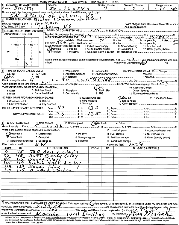
| Owner: McDowell, Michael and Shannon | Status: Constructed | ||
| Location: T2S, R11W, Sec. 7, SW SE SW | County: Smith | ||
| Directions: from Lebanon: 5 mi N, 3.75 mi W | |||
| Latitude: 39.8870732 | Longitude: -98.6105946 | Datum NAD 27 | |
| Latitude: 39.887086 | Longitude: -98.6109385 | Datum NAD 83 | |
| Longitude and latitude calculated by Survey from township-range-section-quarter calls. Only good to within the quarter call accuracy. | |||
| View well on interactive map | |||
| General Info | ||
| Well Depth: 135 ft. | Elevation: ft. | |
| Static Water Level: 73.58 ft. | Est. Yield: 20 gpm. | |
| Comp. Date: 28-May-2003 | Well Use: Domestic | |
| DWR Applic. #: | Other ID: | |
| Driller Info | ||
| Driller: Leroy Maruhn Well Drilling, Inc. | License #: 165 | |
| Scanned Form | View scan |
|
Chemical Sample Submitted?:
Water Well disinfected?: | ||
| Casing Info | ||
| Casing Type:
Casing Joints: |
Diam: in. to ft | |
| Casing height above land surface: in
Casing Weight: lbs/ft Wall thickness or gauge no.: | ||
| Screen and Perforation Info | ||
| Screen Type: | Screen Openings: | |
| Screen-perforated intervals | From: ft to ft | |
| Gravel pack intervals | From: ft to ft | |
| Grout Info | ||
| Grout used: | From: to ft | |
| Source of Possible Contamination | ||
| Source: | ||
| Direction from well: | Distance: ft | |
| Lithologic Log
(Log data entered by KGS.) | ||
| From: 0 ft. to 75 ft. | top soil and clays | |
| From: 75 ft. to 95 ft. | soft sandy clay | |
| From: 95 ft. to 115 ft. | sandy clay | |
| From: 115 ft. to 119 ft. | broken rock and clay | |
| From: 119 ft. to 127 ft. | sandy clay | |
| From: 127 ft. to 135 ft. | ochre and shale | |