|
|
|
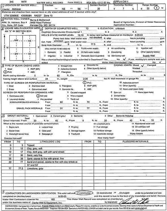
Specific Water Well Detail |
|
|
| Location Info | |||
| Owner: Burns and McDonnell | Status: Constructed | ||
| Location: T7S, R22E, Sec. 20, NE SE | County: Atchison | ||
| Directions: | |||
| Latitude: 39.4241309 | Longitude: -94.9757494 | Datum NAD 27 | |
| Latitude: 39.4241284 | Longitude: -94.9759917 | Datum NAD 83 | |
| Longitude and latitude calculated by Survey from township-range-section-quarter calls. Only good to within the quarter call accuracy. | |||
| View well on interactive map | |||
| General Info | ||
| Well Depth: 72 ft. | Elevation: ft. | |
| Static Water Level: 16.19 ft. | Est. Yield: gpm. | |
| Comp. Date: 20-Aug-2003 | Well Use: Other | |
| DWR Applic. #: | Other ID: A CW 1 | |
| Driller Info | ||
| Driller: Clarke Well and Equipment, Inc. | License #: 185 | |
| Scanned Form | View scan |
|
Chemical Sample Submitted?:
Water Well disinfected?: | ||
| Casing Info | ||
| Casing Type:
Casing Joints: |
Diam: in. to ft | |
| Casing height above land surface: in
Casing Weight: lbs/ft Wall thickness or gauge no.: | ||
| Screen and Perforation Info | ||
| Screen Type: | Screen Openings: | |
| Screen-perforated intervals | From: ft to ft | |
| Gravel pack intervals | From: ft to ft | |
| Grout Info | ||
| Grout used: | From: to ft | |
| Source of Possible Contamination | ||
| Source: | ||
| Direction from well: | Distance: ft | |
| Lithologic Log
(Log data entered by KGS.) | ||
| From: 0 ft. to 3 ft. | top soil | |
| From: 3 ft. to 12 ft. | clay, gray, soft | |
| From: 12 ft. to 17 ft. | clay, dark gray, soft, with sand streaks | |
| From: 17 ft. to 36 ft. | very fine sand | |
| From: 36 ft. to 39 ft. | coarse to fine sand with fine gravel | |
| From: 39 ft. to 77 ft. | coarse to fine sand and gravel with clay streaks at 51 and 53 feet | |
| From: 77 ft. to 77.5 ft. | limestone, gray | |