|
|
|
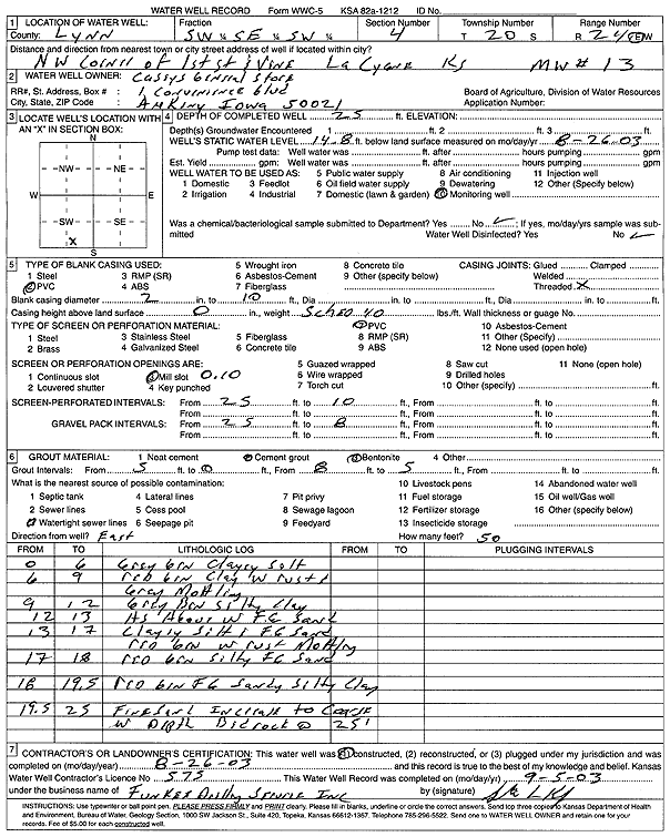
Specific Water Well Detail |
|
|
| Location Info | |||
| Owner: Casey's General Store | Status: Constructed | ||
| Location: T20S, R24E, Sec. 4, SW SE SW | County: Linn | ||
| Directions: NW corner of 1st St and Vine, La Cygne | |||
| Latitude: 38.3314603 | Longitude: -94.7644548 | Datum NAD 27 | |
| Latitude: 38.3314816 | Longitude: -94.7646915 | Datum NAD 83 | |
| Longitude and latitude calculated by Survey from township-range-section-quarter calls. Only good to within the quarter call accuracy. | |||
| View well on interactive map | |||
| General Info | ||
| Well Depth: 25 ft. | Elevation: ft. | |
| Static Water Level: 14.8 ft. | Est. Yield: gpm. | |
| Comp. Date: 26-Aug-2003 | Well Use: Monitoring well/observation/piezometer | |
| DWR Applic. #: | Other ID: MW 13 | |
| Driller Info | ||
| Driller: Funkee Drilling Service | License #: 575 | |
| Scanned Form | View scan |
|
Chemical Sample Submitted?:
Water Well disinfected?: | ||
| Casing Info | ||
| Casing Type:
Casing Joints: |
Diam: in. to ft | |
| Casing height above land surface: in
Casing Weight: lbs/ft Wall thickness or gauge no.: | ||
| Screen and Perforation Info | ||
| Screen Type: | Screen Openings: | |
| Screen-perforated intervals | From: ft to ft | |
| Gravel pack intervals | From: ft to ft | |
| Grout Info | ||
| Grout used: | From: to ft | |
| Source of Possible Contamination | ||
| Source: | ||
| Direction from well: | Distance: ft | |
| Lithologic Log
(Log data entered by KGS.) | ||
| From: 0 ft. to 6 ft. | gray brown clayey silt | |
| From: 6 ft. to 9 ft. | red brown clay with rust and gray mottling | |
| From: 9 ft. to 12 ft. | gray brown silty clay | |
| From: 12 ft. to 13 ft. | gray brown silty clay with fine sand | |
| From: 13 ft. to 17 ft. | clayey silt and fine sand, red brown with rust mottling | |
| From: 17 ft. to 18 ft. | red brown silty fine sand | |
| From: 18 ft. to 19.5 ft. | red brown fine sandy silty clay | |
| From: 19.5 ft. to 25 ft. | fine sand increases to coarse with depth | |
| From: 25 ft. to ft. | bedrock | |