|
|
|
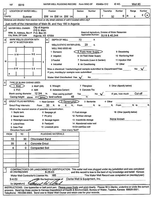
Specific Water Well Detail |
|
|
| Location Info | |||
| Owner: City of Argonia | Status: Plugged | ||
| Location: T32S, R4W, Sec. 9, SW SW SW | County: Sumner | ||
| Directions: from Main St and Hwy 160: N, Argonia | |||
| Latitude: 37.2716132 | Longitude: -97.7640288 | Datum NAD 27 | |
| Latitude: 37.2716338 | Longitude: -97.7643601 | Datum NAD 83 | |
| Longitude and latitude calculated by Survey from township-range-section-quarter calls. Only good to within the quarter call accuracy. | |||
| View well on interactive map | |||
| General Info | ||
| Well Depth: 72 ft. | Elevation: ft. | |
| Static Water Level: 20 ft. | Est. Yield: gpm. | |
| Comp. Date: 26-Aug-2003 | Well Use: Public Water Supply | |
| DWR Applic. #: 40344 | Other ID: Well 3 | |
| Links | |
| View info from Wizard Water Level Data base... | |
| View info from WIMAS Water Right Data base... | |
| Driller Info | ||
| Driller: Clarke Well and Equipment, Inc. | License #: 185 | |
| Scanned Form | View scan |
| Casing Info | ||
|
Casing Type:
Diam: in. Casing height above land surface: in | ||
| Grout Info | ||
| Grout used: | From: to ft | |
| Source of Possible Contamination | ||
| Source: | ||
| Direction from well: | Distance: ft | |