|
|
|
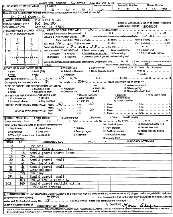
Specific Water Well Detail |
|
|
| Location Info | |||
| Owner: R and B Oil and Gas | Status: Constructed | ||
| Location: T31S, R10W, Sec. 14, SW SW SE | County: Barber | ||
| Directions: from Sharon 6 mi N, 2 mi E | |||
| Latitude: 37.3413724 | Longitude: -98.3752526 | Datum NAD 27 | |
| Latitude: 37.3413932 | Longitude: -98.3756052 | Datum NAD 83 | |
| Longitude and latitude calculated by Survey from township-range-section-quarter calls. Only good to within the quarter call accuracy. | |||
| View well on interactive map | |||
| General Info | ||
| Well Depth: 160 ft. | Elevation: ft. | |
| Static Water Level: 98 ft. | Est. Yield: gpm. | |
| Comp. Date: 26-Jun-2003 | Well Use: Oil Field Water Supply | |
| DWR Applic. #: 20030109 | Other ID: | |
| Links | |
| No Wizard information available. | |
| View info from WIMAS Water Right Data base... | |
| Driller Info | ||
| Driller: Rosencrantz-Bemis Enterprises, Inc. | License #: 134 | |
| Scanned Form | View scan |
|
Chemical Sample Submitted?:
Water Well disinfected?: | ||
| Casing Info | ||
| Casing Type:
Casing Joints: |
Diam: in. to ft | |
| Casing height above land surface: in
Casing Weight: lbs/ft Wall thickness or gauge no.: | ||
| Screen and Perforation Info | ||
| Screen Type: | Screen Openings: | |
| Screen-perforated intervals | From: ft to ft | |
| Gravel pack intervals | From: ft to ft | |
| Grout Info | ||
| Grout used: | From: to ft | |
| Source of Possible Contamination | ||
| Source: | ||
| Direction from well: | Distance: ft | |
| Lithologic Log
(Log data entered by KGS.) | ||
| From: 0 ft. to 3 ft. | top soil | |
| From: 3 ft. to 7 ft. | sandy reddish brown clay | |
| From: 7 ft. to 18 ft. | sand and gravel, coarse, loose | |
| From: 18 ft. to 20 ft. | tan clay | |
| From: 20 ft. to 32 ft. | sand and gravel, small | |
| From: 32 ft. to 41 ft. | tan clay and ash | |
| From: 41 ft. to 56 ft. | sand and gravel, small | |
| From: 56 ft. to 57 ft. | cemented sand | |
| From: 57 ft. to 59.5 ft. | tan clay | |
| From: 59.5 ft. to 81 ft. | sand and gravel, small | |
| From: 81 ft. to 103 ft. | tan, yellow, and gray clay | |
| From: 103 ft. to 160 ft. | sand and gravel, small, tight, with a few clay streaks | |