|
|
|
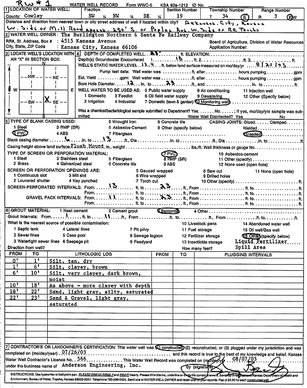
Specific Water Well Detail |
|
|
| Location Info | |||
| Owner: Burlington Northern and Santa Fe Railway Co. | Status: Constructed | ||
| Location: T34S, R3E, Sec. 19, SW NW SE | County: Cowley | ||
| Directions: W side of Mill Rd, 250 feet S of Poplar Ave, W side of RR tracks, Arkansas City | |||
| Latitude: 37.0751988 | Longitude: -97.138265 | Datum NAD 27 | |
| Latitude: 37.0752269 | Longitude: -97.1385829 | Datum NAD 83 | |
| Longitude and latitude calculated by Survey from township-range-section-quarter calls. Only good to within the quarter call accuracy. | |||
| View well on interactive map | |||
| General Info | ||
| Well Depth: 23 ft. | Elevation: ft. | |
| Static Water Level: 13.4 ft. | Est. Yield: gpm. | |
| Comp. Date: 26-Jul-2003 | Well Use: Monitoring well/observation/piezometer | |
| DWR Applic. #: | Other ID: RW 1 | |
| Driller Info | ||
| Driller: Anderson Engineering, Inc. | License #: 566 | |
| Scanned Form | View scan |
|
Chemical Sample Submitted?:
Water Well disinfected?: | ||
| Casing Info | ||
| Casing Type:
Casing Joints: |
Diam: in. to ft | |
| Casing height above land surface: in
Casing Weight: lbs/ft Wall thickness or gauge no.: | ||
| Screen and Perforation Info | ||
| Screen Type: | Screen Openings: | |
| Screen-perforated intervals | From: ft to ft | |
| Gravel pack intervals | From: ft to ft | |
| Grout Info | ||
| Grout used: | From: to ft | |
| Source of Possible Contamination | ||
| Source: | ||
| Direction from well: | Distance: ft | |
| Lithologic Log
(Log data entered by KGS.) | ||
| From: 0 ft. to 1 ft. | silt, tan, dry | |
| From: 1 ft. to 6 ft. | clayey silt, brown | |
| From: 6 ft. to 10 ft. | very clayey silt, dark brown, moist | |
| From: 10 ft. to 18 ft. | clay, more clayey with depth | |
| From: 18 ft. to 22 ft. | silty sand, light gray, saturated | |
| From: 22 ft. to 23 ft. | sand and gravel, light gray, saturated | |