|
|
|
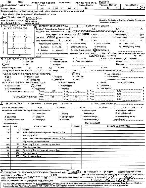
Specific Water Well Detail |
|
|
| Location Info | |||
| Owner: Carl Allam Oil Co. | Status: Constructed | ||
| Location: T24S, R4W, Sec. 20, C N2 SW | County: Reno | ||
| Directions: from Haven: .25 mi W, 3.25 mi N | |||
| Latitude: 37.9468494 | Longitude: -97.7888133 | Datum NAD 27 | |
| Latitude: 37.9468609 | Longitude: -97.7891404 | Datum NAD 83 | |
| Longitude and latitude calculated by Survey from township-range-section-quarter calls. Only good to within the quarter call accuracy. | |||
| View well on interactive map | |||
| General Info | ||
| Well Depth: 118 ft. | Elevation: ft. | |
| Static Water Level: 11.47 ft. | Est. Yield: gpm. | |
| Comp. Date: 02-Sep-2003 | Well Use: Monitoring well/observation/piezometer | |
| DWR Applic. #: | Other ID: MW 03-10 | |
| Driller Info | ||
| Driller: Clarke Well and Equipment, Inc. | License #: 185 | |
| Scanned Form | View scan |
|
Chemical Sample Submitted?:
Water Well disinfected?: | ||
| Casing Info | ||
| Casing Type:
Casing Joints: |
Diam: in. to ft | |
| Casing height above land surface: in
Casing Weight: lbs/ft Wall thickness or gauge no.: | ||
| Screen and Perforation Info | ||
| Screen Type: | Screen Openings: | |
| Screen-perforated intervals | From: ft to ft | |
| Gravel pack intervals | From: ft to ft | |
| Grout Info | ||
| Grout used: | From: to ft | |
| Source of Possible Contamination | ||
| Source: | ||
| Direction from well: | Distance: ft | |
| Lithologic Log
(Log data entered by KGS.) | ||
| From: 0 ft. to 2 ft. | top soil | |
| From: 2 ft. to 33 ft. | coarse to fine sand with medium to fine gravel and clay streaks | |
| From: 33 ft. to 60 ft. | fine to coarse sand with medium to fine gravel and clay streaks, yellowish brown | |
| From: 60 ft. to 89 ft. | very fine to coarse sand with fine gravel | |
| From: 89 ft. to 90 ft. | clay, light gray, hard | |
| From: 90 ft. to 114 ft. | very fine to coarse sand with fine gravel | |
| From: 114 ft. to 121 ft. | sandy clay, tan | |
| From: 121 ft. to 125 ft. | clay, dark gray, hard | |