|
|
|
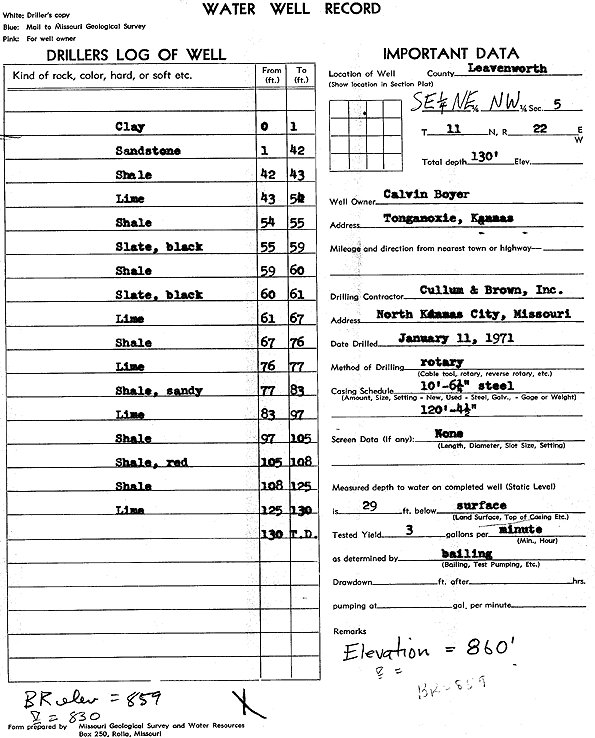
Specific Water Well Detail |
|
|
| Location Info | |||
| Owner: Boyer, Calvin | Status: Constructed | ||
| Location: T11S, R22E, Sec. 5, SE NE NW | County: Leavenworth | ||
| Directions: Tonganoxie | |||
| Latitude: 39.1263281 | Longitude: -94.9930933 | Datum NAD 27 | |
| Latitude: 39.1263305 | Longitude: -94.9933378 | Datum NAD 83 | |
| Longitude and latitude calculated by Survey from township-range-section-quarter calls. Only good to within the quarter call accuracy. | |||
| View well on interactive map | |||
| General Info | ||
| Well Depth: 130 ft. | Elevation: 859 ft. | |
| Static Water Level: 29 ft. | Est. Yield: 3 gpm. | |
| Comp. Date: 11-Jan-1971 | Well Use: (unstated)/abandoned | |
| DWR Applic. #: | Other ID: | |
| Driller Info | ||
| Driller: Cullum and Brown, Inc. | License #: | |
| Scanned Form | View scan |
|
Chemical Sample Submitted?:
Water Well disinfected?: | ||
| Casing Info | ||
| Casing Type:
Casing Joints: |
Diam: in. to ft | |
| Casing height above land surface: in
Casing Weight: lbs/ft Wall thickness or gauge no.: | ||
| Screen and Perforation Info | ||
| Screen Type: | Screen Openings: | |
| Screen-perforated intervals | From: ft to ft | |
| Gravel pack intervals | From: ft to ft | |
| Grout Info | ||
| Grout used: | From: to ft | |
| Source of Possible Contamination | ||
| Source: | ||
| Direction from well: | Distance: ft | |
| Lithologic Log
(Log data entered by KGS.) | ||
| From: 0 ft. to 1 ft. | clay | |
| From: 1 ft. to 42 ft. | sandstone | |
| From: 42 ft. to 43 ft. | shale | |
| From: 43 ft. to 54 ft. | limestone | |
| From: 54 ft. to 55 ft. | shale | |
| From: 55 ft. to 59 ft. | slate, black | |
| From: 59 ft. to 60 ft. | shale | |
| From: 60 ft. to 61 ft. | slate, black | |
| From: 61 ft. to 67 ft. | limestone | |
| From: 67 ft. to 76 ft. | shale | |
| From: 76 ft. to 77 ft. | limestone | |
| From: 77 ft. to 83 ft. | sandy shale | |
| From: 83 ft. to 97 ft. | limestone | |
| From: 97 ft. to 105 ft. | shale | |
| From: 105 ft. to 108 ft. | shale, red | |
| From: 108 ft. to 125 ft. | shale | |
| From: 125 ft. to 130 ft. | limestone | |