|
|
|
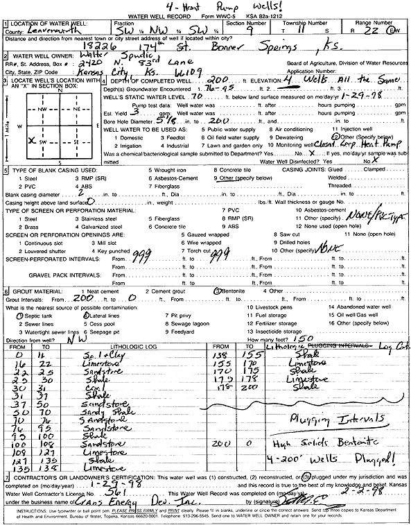
Specific Water Well Detail |
|
|
| Location Info | |||
| Owner: Spudic, Walter | Status: Plugged | ||
| Location: T11S, R22E, Sec. 9, SW NW SW | County: Leavenworth | ||
| Directions: 18226 174th St, Bonner Springs (four 200-foot bores) | |||
| Latitude: 39.1062696 | Longitude: -94.9814897 | Datum NAD 27 | |
| Latitude: 39.1062722 | Longitude: -94.9817342 | Datum NAD 83 | |
| Longitude and latitude calculated by Survey from township-range-section-quarter calls. Only good to within the quarter call accuracy. | |||
| View well on interactive map | |||
| General Info | ||
| Well Depth: 200 ft. | Elevation: ft. | |
| Static Water Level: 70 ft. | Est. Yield: 3 gpm. | |
| Comp. Date: 29-Jan-1998 | Well Use: Heat Pump (Closed Loop/Disposal), Geothermal | |
| DWR Applic. #: | Other ID: | |
| Driller Info | ||
| Driller: Evans Energy Development, Inc. | License #: 561 | |
| Scanned Form | View scan |
| Casing Info | ||
|
Casing Type:
Diam: in. Casing height above land surface: in | ||
| Grout Info | ||
| Grout used: | From: to ft | |
| Source of Possible Contamination | ||
| Source: | ||
| Direction from well: | Distance: ft | |