|
|
|
Specific Water Well Detail |
|
|
| Location Info | |||
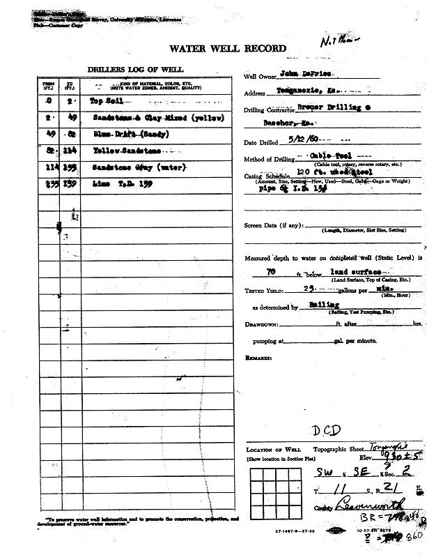
| Owner: DeFries, John | Status: Constructed | ||
| Location: T11S, R21E, Sec. 2, SW SE | County: Leavenworth | ||
| Directions: Tonganoxie | |||
| Latitude: 39.1179285 | Longitude: -95.0444565 | Datum NAD 27 | |
| Latitude: 39.1179306 | Longitude: -95.0447021 | Datum NAD 83 | |
| Longitude and latitude calculated by Survey from township-range-section-quarter calls. Only good to within the quarter call accuracy. | |||
| View well on interactive map | |||
| General Info | ||
| Well Depth: 139 ft. | Elevation: 930 ft. | |
| Static Water Level: 70 ft. | Est. Yield: 25 gpm. | |
| Comp. Date: 12-May-1960 | Well Use: (unstated)/abandoned | |
| DWR Applic. #: | Other ID: | |
| Driller Info | ||
| Driller: Breuer Drilling Co. | License #: | |
| Scanned Form | View scan |
|
Chemical Sample Submitted?:
Water Well disinfected?: | ||
| Casing Info | ||
| Casing Type:
Casing Joints: |
Diam: in. to ft | |
| Casing height above land surface: in
Casing Weight: lbs/ft Wall thickness or gauge no.: | ||
| Screen and Perforation Info | ||
| Screen Type: | Screen Openings: | |
| Screen-perforated intervals | From: ft to ft | |
| Gravel pack intervals | From: ft to ft | |
| Grout Info | ||
| Grout used: | From: to ft | |
| Source of Possible Contamination | ||
| Source: | ||
| Direction from well: | Distance: ft | |
| Lithologic Log
(Log data entered by KGS.) | ||
| From: 0 ft. to 2 ft. | top soil | |
| From: 2 ft. to 49 ft. | sandstone and clay mixed, yellow | |
| From: 49 ft. to 82 ft. | sandy blue drift | |
| From: 82 ft. to 114 ft. | sandstone, yellow | |
| From: 114 ft. to 135 ft. | sandstone, gray | |
| From: 135 ft. to 139 ft. | limestone | |