|
|
|
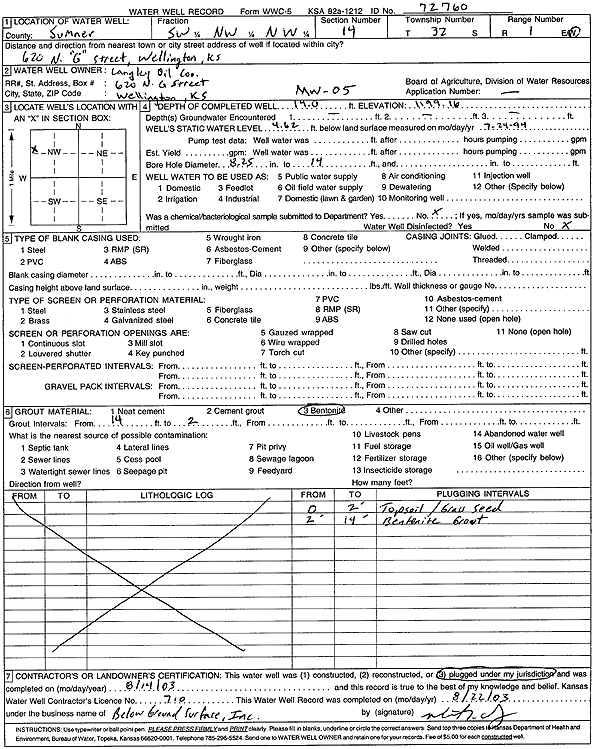
Specific Water Well Detail |
|
|
| Location Info | |||
| Owner: Langley Oil Co. | Status: Plugged | ||
| Location: T32S, R1W, Sec. 14, SW NW NW | County: Sumner | ||
| Directions: 620 N G St, Wellington (tag 72760) | |||
| Latitude: 37.2720493 | Longitude: -97.4016542 | Datum NAD 27 | |
| Latitude: 37.2720715 | Longitude: -97.4019778 | Datum NAD 83 | |
| Longitude and latitude calculated by Survey from township-range-section-quarter calls. Only good to within the quarter call accuracy. | |||
| View well on interactive map | |||
| General Info | ||
| Well Depth: 14 ft. | Elevation: 1199.16 ft. | |
| Static Water Level: 4.62 ft. | Est. Yield: gpm. | |
| Comp. Date: 14-Aug-2003 | Well Use: Monitoring well/observation/piezometer | |
| DWR Applic. #: | Other ID: MW 5 | |
| Driller Info | ||
| Driller: Below Ground Surface, Inc. | License #: 710 | |
| Scanned Form | View scan |
| Casing Info | ||
|
Casing Type:
Diam: in. Casing height above land surface: in | ||
| Grout Info | ||
| Grout used: | From: to ft | |
| Source of Possible Contamination | ||
| Source: | ||
| Direction from well: | Distance: ft | |