|
|
|
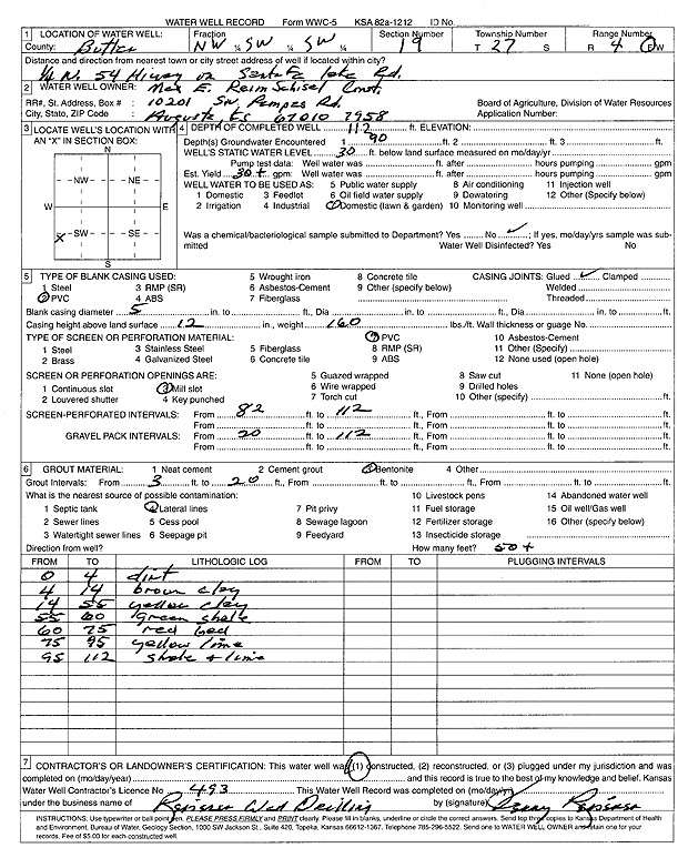
Specific Water Well Detail |
|
|
| Location Info | |||
| Owner: Max E. Reimschisel Construction | Status: Constructed | ||
| Location: T27S, R4E, Sec. 19, NW SW SW | County: Butler | ||
| Directions: from Hwy 54 on Santa Fe Lake Rd: .25 mi N | |||
| Latitude: 37.6823376 | Longitude: -97.0423967 | Datum NAD 27 | |
| Latitude: 37.6823546 | Longitude: -97.0427123 | Datum NAD 83 | |
| Longitude and latitude calculated by Survey from township-range-section-quarter calls. Only good to within the quarter call accuracy. | |||
| View well on interactive map | |||
| General Info | ||
| Well Depth: 112 ft. | Elevation: ft. | |
| Static Water Level: 30 ft. | Est. Yield: 30 gpm. | |
| Comp. Date: 01-Aug-2003 | Well Use: Domestic, Lawn and Garden | |
| DWR Applic. #: | Other ID: | |
| Driller Info | ||
| Driller: Jerry Reiserer Well Drilling | License #: 493 | |
| Scanned Form | View scan |
|
Chemical Sample Submitted?:
Water Well disinfected?: | ||
| Casing Info | ||
| Casing Type:
Casing Joints: |
Diam: in. to ft | |
| Casing height above land surface: in
Casing Weight: lbs/ft Wall thickness or gauge no.: | ||
| Screen and Perforation Info | ||
| Screen Type: | Screen Openings: | |
| Screen-perforated intervals | From: ft to ft | |
| Gravel pack intervals | From: ft to ft | |
| Grout Info | ||
| Grout used: | From: to ft | |
| Source of Possible Contamination | ||
| Source: | ||
| Direction from well: | Distance: ft | |
| Lithologic Log
(Log data entered by KGS.) | ||
| From: 0 ft. to 4 ft. | dirt | |
| From: 4 ft. to 14 ft. | brown clay | |
| From: 14 ft. to 55 ft. | yellow clay | |
| From: 55 ft. to 60 ft. | green shale | |
| From: 60 ft. to 75 ft. | red bed | |
| From: 75 ft. to 95 ft. | yellow limestone | |
| From: 95 ft. to 112 ft. | shale and limestone | |