|
|
|
Specific Water Well Detail |
|
|
| Location Info | |||
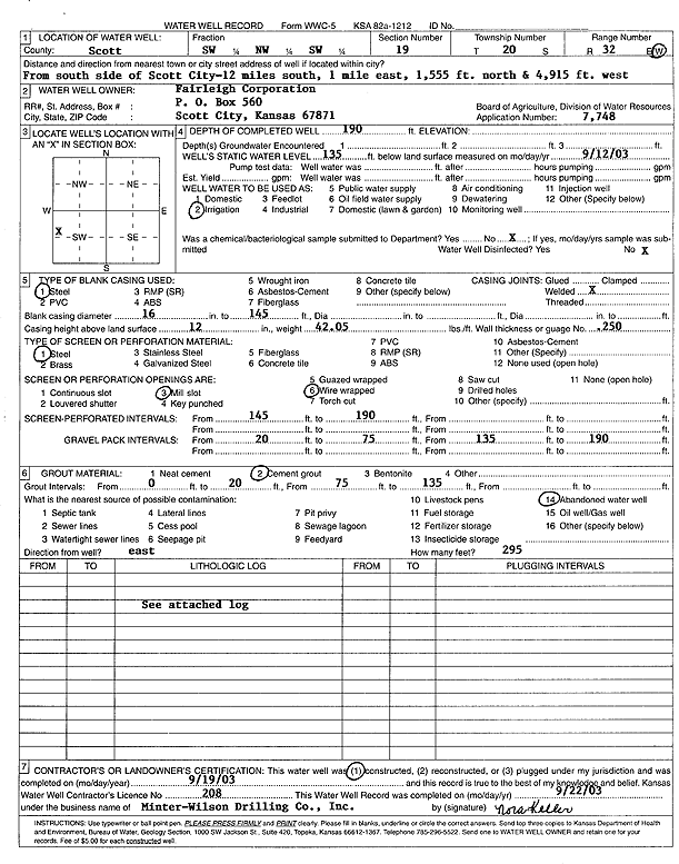
| Owner: Fairleigh Corp. | Status: Constructed | ||
| Location: T20S, R32W, Sec. 19, SW NW SW | County: Scott | ||
| Directions: from S side of Scott City: 12 mi S, 1 mi E, 1555' N, 4915' W | |||
| Latitude: 38.2987061 | Longitude: -100.9035256 | Datum NAD 27 | |
| Latitude: 38.2987276 | Longitude: -100.903959 | Datum NAD 83 | |
| Longitude and latitude calculated by Survey from township-range-section-quarter calls. Only good to within the quarter call accuracy. | |||
| View well on interactive map | |||
| General Info | ||
| Well Depth: 190 ft. | Elevation: ft. | |
| Static Water Level: 135 ft. | Est. Yield: gpm. | |
| Comp. Date: 19-Sep-2003 | Well Use: Irrigation | |
| DWR Applic. #: 7748 | Other ID: | |
| Links | |
| No Wizard information available. | |
| View info from WIMAS Water Right Data base... | |
| Driller Info | ||
| Driller: Minter-Wilson Drlg. Co., Inc. | License #: 208 | |
| Scanned Form | View scan |
|
Chemical Sample Submitted?:
Water Well disinfected?: | ||
| Casing Info | ||
| Casing Type:
Casing Joints: |
Diam: in. to ft | |
| Casing height above land surface: in
Casing Weight: lbs/ft Wall thickness or gauge no.: | ||
| Screen and Perforation Info | ||
| Screen Type: | Screen Openings: | |
| Screen-perforated intervals | From: ft to ft | |
| Gravel pack intervals | From: ft to ft | |
| Grout Info | ||
| Grout used: | From: to ft | |
| Source of Possible Contamination | ||
| Source: | ||
| Direction from well: | Distance: ft | |
| Lithologic Log
(Log data entered by KGS.) | ||
| From: 0 ft. to 1 ft. | Top soil | |
| From: 1 ft. to 6 ft. | Brown clay | |
| From: 6 ft. to 28 ft. | Brown sandy clay | |
| From: 28 ft. to 48 ft. | Brown clay | |
| From: 48 ft. to 55 ft. | Blue clay | |
| From: 55 ft. to 60 ft. | Fine sand | |
| From: 60 ft. to 85 ft. | Brown clay | |
| From: 85 ft. to 93 ft. | Fine to medium sand | |
| From: 93 ft. to 116 ft. | Brown sandy clay | |
| From: 116 ft. to 141 ft. | Brown clay with white rock | |
| From: 141 ft. to 160 ft. | Fine to medium sand and gravel and fine gravel, loose | |
| From: 160 ft. to 175 ft. | Fine to medium sand and gravel | |
| From: 175 ft. to 189 ft. | Yellow clay | |
| From: 189 ft. to 200 ft. | Shale | |