|
|
|
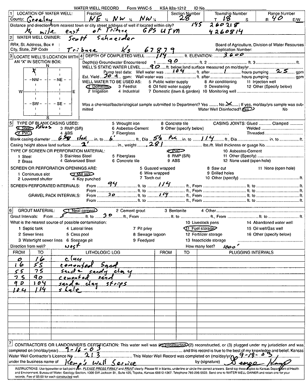
Specific Water Well Detail |
|
|
| Location Info | |||
| Owner: Schneider, Scott | Status: Constructed | ||
| Location: T18S, R40W, Sec. 28, NE NW NW | County: Greeley | ||
| Directions: from Tribune: .25 mi E | |||
| Latitude: 38.4649285 | Longitude: -101.7485383 | Datum NAD 27 | |
| Latitude: 38.4649441 | Longitude: -101.7489883 | Datum NAD 83 | |
| Longitude and latitude calculated by Survey from township-range-section-quarter calls. Only good to within the quarter call accuracy. | |||
| View well on interactive map | |||
| General Info | ||
| Well Depth: 114 ft. | Elevation: 3600 ft. | |
| Static Water Level: 90 ft. | Est. Yield: 30 gpm. | |
| Comp. Date: 16-Sep-2003 | Well Use: Domestic | |
| DWR Applic. #: | Other ID: | |
| Driller Info | ||
| Driller: George Kemp's Well Service | License #: 213 | |
| Scanned Form | View scan |
|
Chemical Sample Submitted?:
Water Well disinfected?: | ||
| Casing Info | ||
| Casing Type:
Casing Joints: |
Diam: in. to ft | |
| Casing height above land surface: in
Casing Weight: lbs/ft Wall thickness or gauge no.: | ||
| Screen and Perforation Info | ||
| Screen Type: | Screen Openings: | |
| Screen-perforated intervals | From: ft to ft | |
| Gravel pack intervals | From: ft to ft | |
| Grout Info | ||
| Grout used: | From: to ft | |
| Source of Possible Contamination | ||
| Source: | ||
| Direction from well: | Distance: ft | |
| Lithologic Log
(Log data entered by KGS.) | ||
| From: 0 ft. to 16 ft. | Clay | |
| From: 16 ft. to 55 ft. | Cemented sand | |
| From: 55 ft. to 75 ft. | Sand and sandy clay | |
| From: 75 ft. to 90 ft. | Cemented sand | |
| From: 90 ft. to 104 ft. | Sandy clay strips | |
| From: 104 ft. to 114 ft. | Shale | |