|
|
|
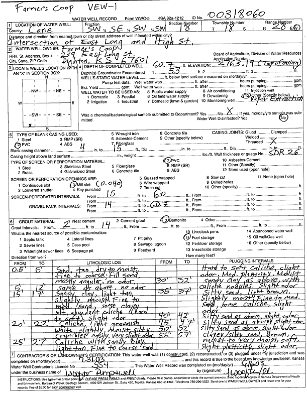
Specific Water Well Detail |
|
|
| Location Info | |||
| Owner: Farmers Coop | Status: Constructed | ||
| Location: T18S, R28W, Sec. 18, SW SE SW SW | County: Lane | ||
| Directions: E Long and High St, Dighton (tag 00318060) | |||
| Latitude: 38.4825446 | Longitude: -100.4637899 | Datum NAD 27 | |
| Latitude: 38.4825614 | Longitude: -100.4642076 | Datum NAD 83 | |
| Longitude and latitude calculated by Survey from township-range-section-quarter calls. Only good to within the quarter call accuracy. | |||
| View well on interactive map | |||
| General Info | ||
| Well Depth: 60.7 ft. | Elevation: 2763.19 ft. | |
| Static Water Level: ft. | Est. Yield: gpm. | |
| Comp. Date: 31-Jul-2003 | Well Use: Environmental Remediation, Soil Vapor Extraction | |
| DWR Applic. #: | Other ID: VEW 1 | |
| Driller Info | ||
| Driller: Jay C. Woofter Pump & Well, Inc. | License #: 554 | |
| Scanned Form | View scan |
|
Chemical Sample Submitted?:
Water Well disinfected?: | ||
| Casing Info | ||
| Casing Type:
Casing Joints: |
Diam: in. to ft | |
| Casing height above land surface: in
Casing Weight: lbs/ft Wall thickness or gauge no.: | ||
| Screen and Perforation Info | ||
| Screen Type: | Screen Openings: | |
| Screen-perforated intervals | From: ft to ft | |
| Gravel pack intervals | From: ft to ft | |
| Grout Info | ||
| Grout used: | From: to ft | |
| Source of Possible Contamination | ||
| Source: | ||
| Direction from well: | Distance: ft | |
| Lithologic Log
(Log data entered by KGS.) | ||
| From: .5 ft. to 5 ft. | Sand, tan, dry to moist, fine to coarse; fill sand, mostly angular, no odor | |
| From: 5 ft. to 12 ft. | Sand, tan, dry to moist, fine to coarse; fill sand, mostly angular, no odor | |
| From: 15 ft. to 17 ft. | Sandy clay, light tan, slightly moist, fine to medium sand, some clayey silt, abundant caliche (hard to soft), slight odor | |
| From: 20 ft. to 22 ft. | Caliche, light greenish white, slightly moist, silty, crumbles easily, very slight odor | |
| From: 25 ft. to 27 ft. | Caliche with sandy clay, light tan, fine to coarse sand, hard to soft caliche, slight odor, medium plasticity, moist | |
| From: 30 ft. to 32 ft. | Sandy clay as above, with caliche nodules, slight odor | |
| From: 35 ft. to 37 ft. | Silty sand, light brown, slightly moist, fine to medium sand, some caliche, slight odor | |
| From: 40 ft. to 42 ft. | Silty sand as above, slight odor | |
| From: 45 ft. to 47 ft. | Silty sand as above, slight odor | |
| From: 50 ft. to 52 ft. | Silty sand as above, slight odor | |
| From: 55 ft. to 57 ft. | Clayey and silty sand, brown, moist to very moist, soft, slight -plasticity, slight odor | |