|
|
|
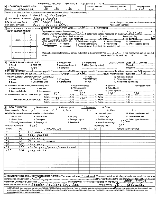
Specific Water Well Detail |
|
|
| Location Info | |||
| Owner: Sender, Sharon | Status: Constructed | ||
| Location: T6S, R17E, Sec. 36, SW SW SW | County: Atchison | ||
| Directions: from Arrington: 3 mi E, 1 mi N | |||
| Latitude: 39.479492 | Longitude: -95.4768868 | Datum NAD 27 | |
| Latitude: 39.4794904 | Longitude: -95.477141 | Datum NAD 83 | |
| Longitude and latitude calculated by Survey from township-range-section-quarter calls. Only good to within the quarter call accuracy. | |||
| View well on interactive map | |||
| General Info | ||
| Well Depth: 120 ft. | Elevation: ft. | |
| Static Water Level: 32.417 ft. | Est. Yield: 1.5 gpm. | |
| Comp. Date: 09-Sep-2003 | Well Use: Domestic | |
| DWR Applic. #: | Other ID: | |
| Driller Info | ||
| Driller: Strader Drilling Co., Inc. | License #: 182 | |
| Scanned Form | View scan |
|
Chemical Sample Submitted?:
Water Well disinfected?: | ||
| Casing Info | ||
| Casing Type:
Casing Joints: |
Diam: in. to ft | |
| Casing height above land surface: in
Casing Weight: lbs/ft Wall thickness or gauge no.: | ||
| Screen and Perforation Info | ||
| Screen Type: | Screen Openings: | |
| Screen-perforated intervals | From: ft to ft | |
| Gravel pack intervals | From: ft to ft | |
| Grout Info | ||
| Grout used: | From: to ft | |
| Source of Possible Contamination | ||
| Source: | ||
| Direction from well: | Distance: ft | |
| Lithologic Log
(Log data entered by KGS.) | ||
| From: 0 ft. to 1 ft. | Topsoil | |
| From: 1 ft. to 42 ft. | Clay, yellow | |
| From: 42 ft. to 53 ft. | Clay, gray | |
| From: 53 ft. to 58 ft. | Fine sand, brown | |
| From: 58 ft. to 107 ft. | Clay, gray | |
| From: 107 ft. to 111 ft. | Shale, gray/green/weathered | |
| From: 111 ft. to 120 ft. | Shale, gray | |