|
|
|
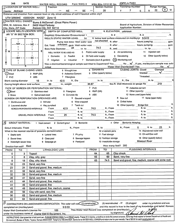
Specific Water Well Detail |
|
|
| Location Info | |||
| Owner: Burns and McDonnell (Great Plains Power) | Status: Constructed | ||
| Location: T7S, R22E, Sec. 20, NE SE | County: Atchison | ||
| Directions: | |||
| Latitude: 39.4241309 | Longitude: -94.9757494 | Datum NAD 27 | |
| Latitude: 39.4241284 | Longitude: -94.9759917 | Datum NAD 83 | |
| Longitude and latitude calculated by Survey from township-range-section-quarter calls. Only good to within the quarter call accuracy. | |||
| View well on interactive map | |||
| General Info | ||
| Well Depth: 77 ft. | Elevation: ft. | |
| Static Water Level: 14 ft. | Est. Yield: gpm. | |
| Comp. Date: 09-Sep-2003 | Well Use: Monitoring well/observation/piezometer | |
| DWR Applic. #: | Other ID: A-TW01 | |
| Driller Info | ||
| Driller: Clarke Well and Equipment, Inc. | License #: 185 | |
| Scanned Form | View scan |
|
Chemical Sample Submitted?:
Water Well disinfected?: | ||
| Casing Info | ||
| Casing Type:
Casing Joints: |
Diam: in. to ft | |
| Casing height above land surface: in
Casing Weight: lbs/ft Wall thickness or gauge no.: | ||
| Screen and Perforation Info | ||
| Screen Type: | Screen Openings: | |
| Screen-perforated intervals | From: ft to ft | |
| Gravel pack intervals | From: ft to ft | |
| Grout Info | ||
| Grout used: | From: to ft | |
| Source of Possible Contamination | ||
| Source: | ||
| Direction from well: | Distance: ft | |
| Lithologic Log
(Log data entered by KGS.) | ||
| From: 0 ft. to 3 ft. | top soil | |
| From: 3 ft. to 8 ft. | clay, silty gray | |
| From: 8 ft. to 18 ft. | clay, silty, black | |
| From: 18 ft. to 23 ft. | very fine sand | |
| From: 23 ft. to 31 ft. | fine, medium sand and gravel | |
| From: 31 ft. to 32 ft. | very fine sand | |
| From: 32 ft. to 39 ft. | fine, medium sand and gravel | |
| From: 39 ft. to 41 ft. | very fine sand | |
| From: 41 ft. to 44 ft. | fine, medium sand and gravel | |
| From: 44 ft. to 45 ft. | fine sand and gravel | |
| From: 45 ft. to 49 ft. | fine, medium, coarse sand and gravel | |
| From: 49 ft. to 56 ft. | clay with very fine sand | |
| From: 56 ft. to 62 ft. | fine, medium sand and gravel | |
| From: 62 ft. to 64 ft. | fine sand and gravel | |
| From: 64 ft. to 65 ft. | clay streak | |
| From: 65 ft. to 69 ft. | very fine sand | |
| From: 69 ft. to 74.5 ft. | sand and gravel; fine, medium, coarse; with some rock | |