|
|
|
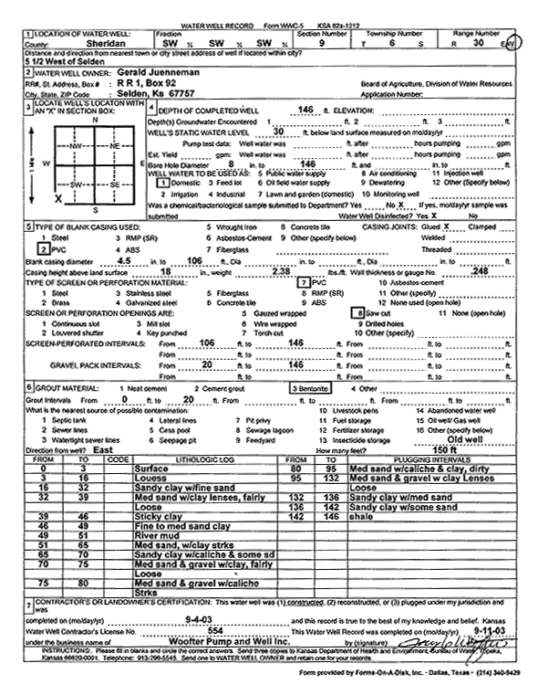
Specific Water Well Detail |
|
|
| Location Info | |||
| Owner: Juenneman, Gerald | Status: Constructed | ||
| Location: T6S, R30W, Sec. 9, SW SW SW | County: Sheridan | ||
| Directions: from Selden: 5.5 mi W | |||
| Latitude: 39.5399679 | Longitude: -100.681339 | Datum NAD 27 | |
| Latitude: 39.5399718 | Longitude: -100.6817638 | Datum NAD 83 | |
| Longitude and latitude calculated by Survey from township-range-section-quarter calls. Only good to within the quarter call accuracy. | |||
| View well on interactive map | |||
| General Info | ||
| Well Depth: 146 ft. | Elevation: ft. | |
| Static Water Level: 30 ft. | Est. Yield: gpm. | |
| Comp. Date: 04-Sep-2003 | Well Use: Domestic | |
| DWR Applic. #: | Other ID: | |
| Driller Info | ||
| Driller: Woofter Pump & Well, Inc. | License #: 554 | |
| Scanned Form | View scan |
|
Chemical Sample Submitted?:
Water Well disinfected?: | ||
| Casing Info | ||
| Casing Type:
Casing Joints: |
Diam: in. to ft | |
| Casing height above land surface: in
Casing Weight: lbs/ft Wall thickness or gauge no.: | ||
| Screen and Perforation Info | ||
| Screen Type: | Screen Openings: | |
| Screen-perforated intervals | From: ft to ft | |
| Gravel pack intervals | From: ft to ft | |
| Grout Info | ||
| Grout used: | From: to ft | |
| Source of Possible Contamination | ||
| Source: | ||
| Direction from well: | Distance: ft | |
| Lithologic Log
(Log data entered by KGS.) | ||
| From: 0 ft. to 3 ft. | Surface | |
| From: 3 ft. to 16 ft. | Loess | |
| From: 16 ft. to 32 ft. | Sandy clay with fine sand | |
| From: 32 ft. to 39 ft. | Medium sand with clay lenses, fairly loose | |
| From: 39 ft. to 46 ft. | Sticky clay | |
| From: 46 ft. to 49 ft. | Fine to medium sand clay | |
| From: 49 ft. to 51 ft. | River mud | |
| From: 51 ft. to 65 ft. | Medium sand, with clay streaks | |
| From: 65 ft. to 70 ft. | Sandy clay with caliche and some sand | |
| From: 70 ft. to 75 ft. | Medium sand and gravel with clay, fairly loose | |
| From: 75 ft. to 80 ft. | Medium sand and gravel with caliche streaks | |
| From: 80 ft. to 95 ft. | Medium sand with caliche and clay, dirty | |
| From: 95 ft. to 132 ft. | Medium sand and gravel with clay lenses loose | |
| From: 132 ft. to 136 ft. | Sandy clay with medium sand | |
| From: 136 ft. to 142 ft. | Sandy clay with some sand | |
| From: 142 ft. to 146 ft. | Shale | |