|
|
|
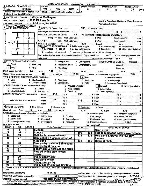
Specific Water Well Detail |
|
|
| Location Info | |||
| Owner: Mollhegen, Kathryn A. | Status: Constructed | ||
| Location: T8S, R25W, Sec. 8, SW SW NW | County: Graham | ||
| Directions: from Studley: 2 mi E, 1 mi N | |||
| Latitude: 39.3722358 | Longitude: -100.1422888 | Datum NAD 27 | |
| Latitude: 39.37224 | Longitude: -100.1426988 | Datum NAD 83 | |
| Longitude and latitude calculated by Survey from township-range-section-quarter calls. Only good to within the quarter call accuracy. | |||
| View well on interactive map | |||
| General Info | ||
| Well Depth: 135 ft. | Elevation: ft. | |
| Static Water Level: ft. | Est. Yield: gpm. | |
| Comp. Date: 16-Sep-2003 | Well Use: Domestic | |
| DWR Applic. #: | Other ID: | |
| Driller Info | ||
| Driller: Jay C. Woofter Pump & Well, Inc. | License #: 554 | |
| Scanned Form | View scan |
|
Chemical Sample Submitted?:
Water Well disinfected?: | ||
| Casing Info | ||
| Casing Type:
Casing Joints: |
Diam: in. to ft | |
| Casing height above land surface: in
Casing Weight: lbs/ft Wall thickness or gauge no.: | ||
| Screen and Perforation Info | ||
| Screen Type: | Screen Openings: | |
| Screen-perforated intervals | From: ft to ft | |
| Gravel pack intervals | From: ft to ft | |
| Grout Info | ||
| Grout used: | From: to ft | |
| Source of Possible Contamination | ||
| Source: | ||
| Direction from well: | Distance: ft | |
| Lithologic Log
(Log data entered by KGS.) | ||
| From: 0 ft. to 3 ft. | surface | |
| From: 3 ft. to 14 ft. | loess | |
| From: 14 ft. to 19 ft. | caliche and cemented sand | |
| From: 19 ft. to 37 ft. | clay caliche and cemented sand with fine sand | |
| From: 37 ft. to 48 ft. | sandy clay, caliche and fine sand | |
| From: 48 ft. to 67 ft. | sandy clay and caliche | |
| From: 67 ft. to 77 ft. | sandy clay and hard caliche streaks | |
| From: 77 ft. to 88 ft. | fine sand with fine clay lenses, loose | |
| From: 88 ft. to 90 ft. | sticky sandy clay | |
| From: 90 ft. to 95 ft. | fine sand with clay | |
| From: 95 ft. to 99 ft. | sticky sandy clay | |
| From: 99 ft. to 106 ft. | sticky sandy clay with a few fine sand streaks | |
| From: 106 ft. to 123 ft. | fine to medium sand with clay layers, loose | |
| From: 123 ft. to 132 ft. | medium sand and gravel with a few clay lenses | |
| From: 132 ft. to 135 ft. | ochre and shale | |