|
|
|
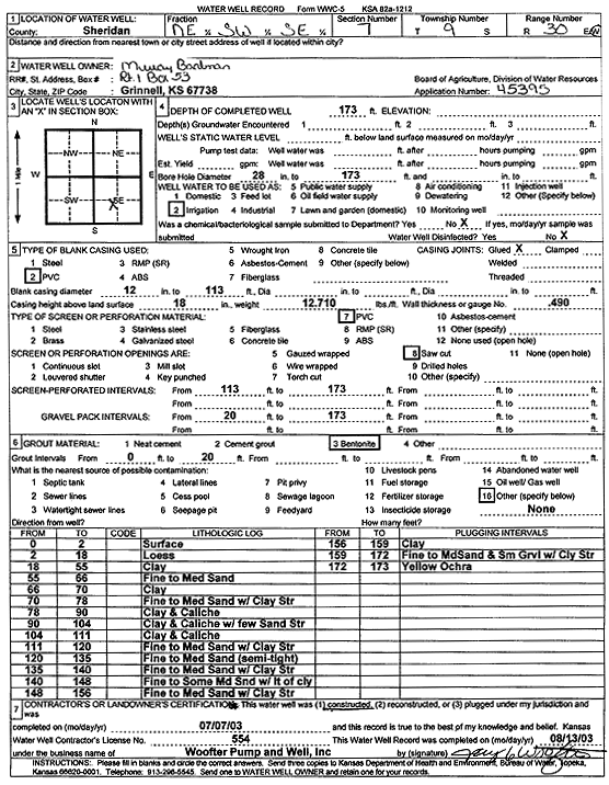
Specific Water Well Detail |
|
|
| Location Info | |||
| Owner: Baalman, Murray | Status: Constructed | ||
| Location: T9S, R30W, Sec. 7, NE SW SE | County: Sheridan | ||
| Directions: | |||
| Latitude: 39.2807668 | Longitude: -100.7081568 | Datum NAD 27 | |
| Latitude: 39.2807727 | Longitude: -100.7085811 | Datum NAD 83 | |
| Longitude and latitude calculated by Survey from township-range-section-quarter calls. Only good to within the quarter call accuracy. | |||
| View well on interactive map | |||
| General Info | ||
| Well Depth: 173 ft. | Elevation: ft. | |
| Static Water Level: ft. | Est. Yield: gpm. | |
| Comp. Date: 07-Jul-2003 | Well Use: Irrigation | |
| DWR Applic. #: 45395 | Other ID: | |
| Links | |
| No Wizard information available. | |
| View info from WIMAS Water Right Data base... | |
| Driller Info | ||
| Driller: Jay C. Woofter Pump & Well, Inc. | License #: 554 | |
| Scanned Form | View scan |
|
Chemical Sample Submitted?:
Water Well disinfected?: | ||
| Casing Info | ||
| Casing Type:
Casing Joints: |
Diam: in. to ft | |
| Casing height above land surface: in
Casing Weight: lbs/ft Wall thickness or gauge no.: | ||
| Screen and Perforation Info | ||
| Screen Type: | Screen Openings: | |
| Screen-perforated intervals | From: ft to ft | |
| Gravel pack intervals | From: ft to ft | |
| Grout Info | ||
| Grout used: | From: to ft | |
| Source of Possible Contamination | ||
| Source: | ||
| Direction from well: | Distance: ft | |
| Lithologic Log
(Log data entered by KGS.) | ||
| From: 0 ft. to 2 ft. | Surface | |
| From: 2 ft. to 18 ft. | Loess | |
| From: 18 ft. to 55 ft. | Clay | |
| From: 55 ft. to 66 ft. | Fine to medium sand | |
| From: 66 ft. to 70 ft. | Clay | |
| From: 70 ft. to 78 ft. | Fine to medium sand with clay streak | |
| From: 78 ft. to 90 ft. | Clay and caliche | |
| From: 90 ft. to 104 ft. | Clay and caliche with few sand streaks | |
| From: 104 ft. to 111 ft. | Clay and caliche | |
| From: 111 ft. to 120 ft. | Fine to medium sand with clay streak | |
| From: 120 ft. to 135 ft. | Fine to medium sand (semi-tight) | |
| From: 135 ft. to 140 ft. | Fine to medium sand with clay streak | |
| From: 140 ft. to 148 ft. | Fine to some medium sand with lt of clay | |
| From: 148 ft. to 156 ft. | Fine to medium sand with clay streak | |
| From: 156 ft. to 159 ft. | Clay | |
| From: 159 ft. to 172 ft. | Fine to medium sand and small gravel with clay streak | |
| From: 172 ft. to 173 ft. | Yellow ochre | |