|
|
|
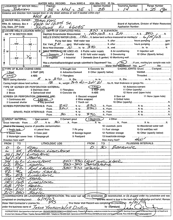
Specific Water Well Detail |
|
|
| Location Info | |||
| Owner: Vore, James | Status: Constructed | ||
| Location: T14S, R25E, Sec. 28, SE NW SE | County: Johnson | ||
| Directions: | |||
| Latitude: 38.8010762 | Longitude: -94.6361952 | Datum NAD 27 | |
| Latitude: 38.8010846 | Longitude: -94.6364293 | Datum NAD 83 | |
| Longitude and latitude calculated by Survey from township-range-section-quarter calls. Only good to within the quarter call accuracy. | |||
| View well on interactive map | |||
| General Info | ||
| Well Depth: 370 ft. | Elevation: ft. | |
| Static Water Level: 122 ft. | Est. Yield: 10 gpm. | |
| Comp. Date: 15-Jun-2003 | Well Use: Domestic | |
| DWR Applic. #: | Other ID: Well 2 | |
| Driller Info | ||
| Driller: Jesse Yoakum Well Drilling | License #: 595 | |
| Scanned Form | View scan |
|
Chemical Sample Submitted?:
Water Well disinfected?: | ||
| Casing Info | ||
| Casing Type:
Casing Joints: |
Diam: in. to ft | |
| Casing height above land surface: in
Casing Weight: lbs/ft Wall thickness or gauge no.: | ||
| Screen and Perforation Info | ||
| Screen Type: | Screen Openings: | |
| Screen-perforated intervals | From: ft to ft | |
| Gravel pack intervals | From: ft to ft | |
| Grout Info | ||
| Grout used: | From: to ft | |
| Source of Possible Contamination | ||
| Source: | ||
| Direction from well: | Distance: ft | |
| Lithologic Log
(Log data entered by KGS.) | ||
| From: 0 ft. to 6 ft. | clay | |
| From: 6 ft. to 25 ft. | broken limestone | |
| From: 25 ft. to 34 ft. | limestone | |
| From: 34 ft. to 54 ft. | shale | |
| From: 54 ft. to 62 ft. | limestone | |
| From: 62 ft. to 86 ft. | shale | |
| From: 86 ft. to 92 ft. | red shale | |
| From: 92 ft. to 96 ft. | gray shale | |
| From: 96 ft. to 103 ft. | limestone | |
| From: 103 ft. to 140 ft. | shale | |
| From: 140 ft. to 168 ft. | limestone | |
| From: 168 ft. to 196 ft. | shale | |
| From: 196 ft. to 210 ft. | slate | |
| From: 210 ft. to 250 ft. | shale | |
| From: 250 ft. to 330 ft. | light gray shale | |
| From: 330 ft. to 350 ft. | sandstone | |
| From: 350 ft. to 370 ft. | shale | |