|
|
|
Specific Water Well Detail |
|
|
| Location Info | |||
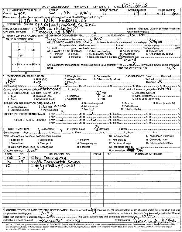
| Owner: S and S Oil and Propane | Status: Constructed | ||
| Location: T19S, R11E, Sec. 11, SW SE NW | County: Lyon | ||
| Directions: 1126 E 12th St, Emporia (tag 00316613) | |||
| Latitude: 38.4131589 | Longitude: -96.1648033 | Datum NAD 27 | |
| Latitude: 38.4131729 | Longitude: -96.1650766 | Datum NAD 83 | |
| Longitude and latitude calculated by Survey from township-range-section-quarter calls. Only good to within the quarter call accuracy. | |||
| View well on interactive map | |||
| General Info | ||
| Well Depth: 15 ft. | Elevation: 1131.08 ft. | |
| Static Water Level: 10.25 ft. | Est. Yield: gpm. | |
| Comp. Date: 18-Sep-2003 | Well Use: Monitoring well/observation/piezometer | |
| DWR Applic. #: | Other ID: MW 11 | |
| Driller Info | ||
| Driller: Associated Environmental, Inc. | License #: 585 | |
| Scanned Form | View scan |
|
Chemical Sample Submitted?:
Water Well disinfected?: | ||
| Casing Info | ||
| Casing Type:
Casing Joints: |
Diam: in. to ft | |
| Casing height above land surface: in
Casing Weight: lbs/ft Wall thickness or gauge no.: | ||
| Screen and Perforation Info | ||
| Screen Type: | Screen Openings: | |
| Screen-perforated intervals | From: ft to ft | |
| Gravel pack intervals | From: ft to ft | |
| Grout Info | ||
| Grout used: | From: to ft | |
| Source of Possible Contamination | ||
| Source: | ||
| Direction from well: | Distance: ft | |
| Lithologic Log
(Log data entered by KGS.) | ||
| From: 0 ft. to 2 ft. | clay, dark gray | |
| From: 2 ft. to 10 ft. | silty clay, reddish brown | |
| From: 10 ft. to ft. | clayey sand with gravel | |