|
|
|
Specific Water Well Detail |
|
|
| Location Info | |||
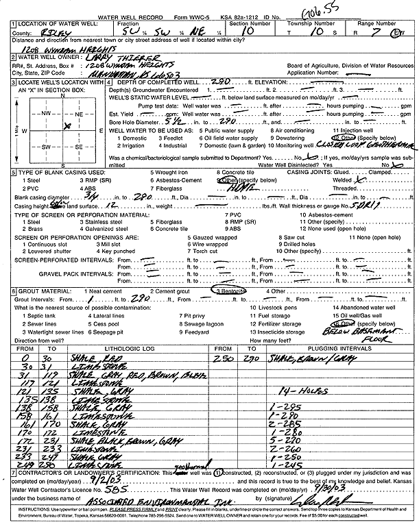
| Owner: Thierer, Larry | Status: Constructed | ||
| Location: T10S, R7E, Sec. 10, SW SW NE | County: Riley | ||
| Directions: 1208 Wyndam Heights, Manhattan (1 bore at 295', 1 bore at 290', 2 bores at 285', 1 bore at 280', 5 bores at 270', 2 at 260', 1 at 250', 1 at 245') | |||
| Latitude: 39.1972849 | Longitude: -96.6340751 | Datum NAD 27 | |
| Latitude: 39.1972818 | Longitude: -96.6343572 | Datum NAD 83 | |
| Longitude and latitude calculated by Survey from township-range-section-quarter calls. Only good to within the quarter call accuracy. | |||
| View well on interactive map | |||
| General Info | ||
| Well Depth: 290 ft. | Elevation: ft. | |
| Static Water Level: ft. | Est. Yield: gpm. | |
| Comp. Date: 02-Sep-2003 | Well Use: Heat Pump (Closed Loop/Disposal), Geothermal | |
| DWR Applic. #: | Other ID: GO 6.55 | |
| Driller Info | ||
| Driller: Associated Environmental, Inc. | License #: 585 | |
| Scanned Form | View scan |
|
Chemical Sample Submitted?:
Water Well disinfected?: | ||
| Casing Info | ||
| Casing Type:
Casing Joints: |
Diam: in. to ft | |
| Casing height above land surface: in
Casing Weight: lbs/ft Wall thickness or gauge no.: | ||
| Screen and Perforation Info | ||
| Screen Type: | Screen Openings: | |
| Screen-perforated intervals | From: ft to ft | |
| Gravel pack intervals | From: ft to ft | |
| Grout Info | ||
| Grout used: | From: to ft | |
| Source of Possible Contamination | ||
| Source: | ||
| Direction from well: | Distance: ft | |
| Lithologic Log
(Log data entered by KGS.) | ||
| From: 0 ft. to 30 ft. | shale, red | |
| From: 30 ft. to 31 ft. | limestone | |
| From: 31 ft. to 119 ft. | shale, gray, red, brown, black | |
| From: 119 ft. to 121 ft. | limestone | |
| From: 121 ft. to 135 ft. | shale, gray | |
| From: 135 ft. to 138 ft. | limestone | |
| From: 138 ft. to 158 ft. | shale, gray | |
| From: 158 ft. to 161 ft. | limestone | |
| From: 161 ft. to 170 ft. | shale, gray | |
| From: 170 ft. to 172 ft. | limestone | |
| From: 172 ft. to 231 ft. | shale, black, brown, gray | |
| From: 231 ft. to 233 ft. | limestone | |
| From: 233 ft. to 249 ft. | shale, gray | |
| From: 249 ft. to 250 ft. | limestone | |
| From: 250 ft. to 290 ft. | shale, brown and gray | |