|
|
|
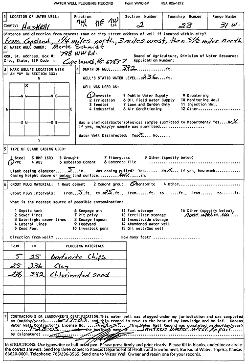
Specific Water Well Detail |
|
|
| Location Info | |||
| Owner: Schmidt, Merle | Status: Plugged | ||
| Location: T28S, R31W, Sec. 2, NW NE NW | County: Haskell | ||
| Directions: from Copeland: 1.25 mi N, 3 mi W, 5.5 mi N | |||
| Latitude: 37.6482734 | Longitude: -100.6827182 | Datum NAD 27 | |
| Latitude: 37.6482974 | Longitude: -100.6831531 | Datum NAD 83 | |
| Longitude and latitude calculated by Survey from township-range-section-quarter calls. Only good to within the quarter call accuracy. | |||
| View well on interactive map | |||
| General Info | ||
| Well Depth: 392 ft. | Elevation: ft. | |
| Static Water Level: 236 ft. | Est. Yield: gpm. | |
| Comp. Date: 17-Jun-2003 | Well Use: Domestic | |
| DWR Applic. #: | Other ID: | |
| Driller Info | ||
| Driller: Ed Jantzen Water Well Repair | License #: 533 | |
| Scanned Form | View scan |
| Casing Info | ||
|
Casing Type:
Diam: in. Casing height above land surface: in | ||
| Grout Info | ||
| Grout used: | From: to ft | |
| Source of Possible Contamination | ||
| Source: | ||
| Direction from well: | Distance: ft | |