|
|
|
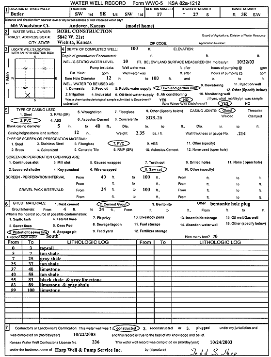
Specific Water Well Detail |
|
|
| Location Info | |||
| Owner: Robl Construction | Status: Constructed | ||
| Location: T27S, R3E, Sec. 17, SW SE SW | County: Butler | ||
| Directions: 606 Woodstone Ct, Andover (model home) | |||
| Latitude: 37.6948678 | Longitude: -97.1291531 | Datum NAD 27 | |
| Latitude: 37.6948835 | Longitude: -97.1294713 | Datum NAD 83 | |
| Longitude and latitude calculated by Survey from township-range-section-quarter calls. Only good to within the quarter call accuracy. | |||
| View well on interactive map | |||
| General Info | ||
| Well Depth: 100 ft. | Elevation: ft. | |
| Static Water Level: 20 ft. | Est. Yield: gpm. | |
| Comp. Date: 22-Oct-2003 | Well Use: Domestic, Lawn and Garden | |
| DWR Applic. #: | Other ID: | |
| Driller Info | ||
| Driller: Harp Well & Pump Service, Inc. | License #: 236 | |
| Scanned Form | View scan |
|
Chemical Sample Submitted?:
Water Well disinfected?: | ||
| Casing Info | ||
| Casing Type:
Casing Joints: |
Diam: in. to ft | |
| Casing height above land surface: in
Casing Weight: lbs/ft Wall thickness or gauge no.: | ||
| Screen and Perforation Info | ||
| Screen Type: | Screen Openings: | |
| Screen-perforated intervals | From: ft to ft | |
| Gravel pack intervals | From: ft to ft | |
| Grout Info | ||
| Grout used: | From: to ft | |
| Source of Possible Contamination | ||
| Source: | ||
| Direction from well: | Distance: ft | |
| Lithologic Log
(Log data entered by KGS.) | ||
| From: 0 ft. to 3 ft. | top soil | |
| From: 3 ft. to 7 ft. | tan shale | |
| From: 7 ft. to 25 ft. | gray shale | |
| From: 25 ft. to 37 ft. | tan shale | |
| From: 37 ft. to 40 ft. | limestone | |
| From: 40 ft. to 55 ft. | tan shale | |
| From: 55 ft. to 83 ft. | black shale and gray limestone | |
| From: 83 ft. to 89 ft. | limestone and gray shale | |
| From: 89 ft. to 100 ft. | limestone | |