|
|
|
Specific Water Well Detail |
|
|
| Location Info | |||
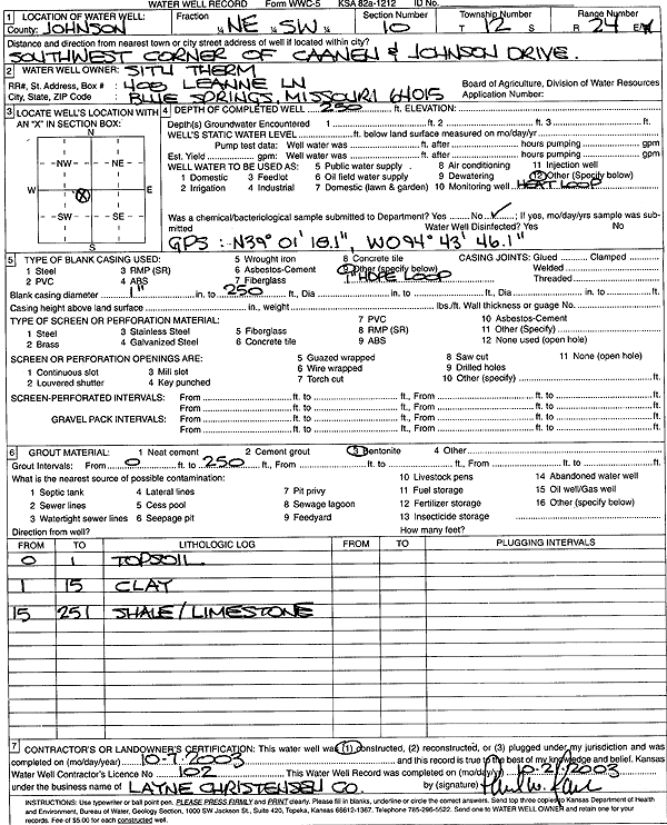
| Owner: Situ Therm | Status: Constructed | ||
| Location: T12S, R24E, Sec. 10, NE SW | County: Johnson | ||
| Directions: SW corner of Caenen and Johnson Dr. | |||
| Latitude: 39.0216863 | Longitude: -94.7292317 | Datum NAD 27 | |
| Latitude: 39.021694 | Longitude: -94.729472 | Datum NAD 83 | |
| Longitude and latitude from GPS measurements. | |||
| GPS Latitude: 39.021694 | GPS Longitude: -94.729472 | Datum NAD83 | |
| View well on interactive map | |||
| General Info | ||
| Well Depth: 250 ft. | Elevation: ft. | |
| Static Water Level: ft. | Est. Yield: gpm. | |
| Comp. Date: 07-Oct-2003 | Well Use: Heat Pump (Closed Loop/Disposal), Geothermal | |
| DWR Applic. #: | Other ID: | |
| Driller Info | ||
| Driller: Layne-Christensen Co. | License #: 102 | |
| Scanned Form | View scan |
|
Chemical Sample Submitted?:
Water Well disinfected?: | ||
| Casing Info | ||
| Casing Type:
Casing Joints: |
Diam: in. to ft | |
| Casing height above land surface: in
Casing Weight: lbs/ft Wall thickness or gauge no.: | ||
| Screen and Perforation Info | ||
| Screen Type: | Screen Openings: | |
| Screen-perforated intervals | From: ft to ft | |
| Gravel pack intervals | From: ft to ft | |
| Grout Info | ||
| Grout used: | From: to ft | |
| Source of Possible Contamination | ||
| Source: | ||
| Direction from well: | Distance: ft | |
| Lithologic Log
(Log data entered by KGS.) | ||
| From: 0 ft. to 1 ft. | top soil | |
| From: 1 ft. to 15 ft. | clay | |
| From: 15 ft. to 251 ft. | shale and limestone | |