|
|
|
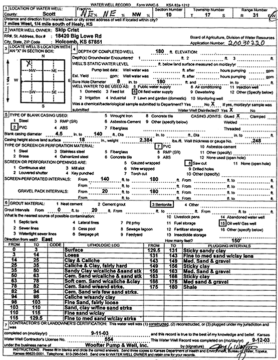
Specific Water Well Detail |
|
|
| Location Info | |||
| Owner: Crist, Skip | Status: Constructed | ||
| Location: T17S, R31W, Sec. 10, NE NE NW | County: Scott | ||
| Directions: from Healy: 7 mi W, .25 mi S | |||
| Latitude: 38.5981251 | Longitude: -100.7340719 | Datum NAD 27 | |
| Latitude: 38.5981413 | Longitude: -100.7344953 | Datum NAD 83 | |
| Longitude and latitude calculated by Survey from township-range-section-quarter calls. Only good to within the quarter call accuracy. | |||
| View well on interactive map | |||
| General Info | ||
| Well Depth: 180 ft. | Elevation: ft. | |
| Static Water Level: ft. | Est. Yield: gpm. | |
| Comp. Date: 11-Sep-2003 | Well Use: Oil Field Water Supply | |
| DWR Applic. #: 20030220 | Other ID: | |
| Links | |
| No Wizard information available. | |
| View info from WIMAS Water Right Data base... | |
| Driller Info | ||
| Driller: Jay C. Woofter Pump & Well, Inc. | License #: 554 | |
| Scanned Form | View scan |
|
Chemical Sample Submitted?:
Water Well disinfected?: | ||
| Casing Info | ||
| Casing Type:
Casing Joints: |
Diam: in. to ft | |
| Casing height above land surface: in
Casing Weight: lbs/ft Wall thickness or gauge no.: | ||
| Screen and Perforation Info | ||
| Screen Type: | Screen Openings: | |
| Screen-perforated intervals | From: ft to ft | |
| Gravel pack intervals | From: ft to ft | |
| Grout Info | ||
| Grout used: | From: to ft | |
| Source of Possible Contamination | ||
| Source: | ||
| Direction from well: | Distance: ft | |
| Lithologic Log
(Log data entered by KGS.) | ||
| From: 0 ft. to 3 ft. | surface | |
| From: 3 ft. to 14 ft. | loess | |
| From: 14 ft. to 25 ft. | clay and caliche | |
| From: 25 ft. to 35 ft. | caliche and clay, fairly hard | |
| From: 35 ft. to 50 ft. | sandy clay with caliche and sand stk | |
| From: 50 ft. to 63 ft. | cem. Sand with caliche and sand stk | |
| From: 63 ft. to 78 ft. | soft cem sand with caliche and clay | |
| From: 78 ft. to 82 ft. | cem sand with sand streaks | |
| From: 82 ft. to 94 ft. | cem sand with a few sand streaks | |
| From: 94 ft. to 98 ft. | caliche with sandy clay | |
| From: 98 ft. to 103 ft. | fine sand, fairly loose | |
| From: 103 ft. to 110 ft. | sand, clay with fine sand streaks | |
| From: 110 ft. to 115 ft. | fine sand with clay | |
| From: 115 ft. to 129.5 ft. | fine to med sand with clay streaks | |
| From: 129.5 ft. to 131 ft. | sticky sandy clay | |
| From: 131 ft. to 143 ft. | fine to med sand with clay lens | |
| From: 143 ft. to 149 ft. | medium sand and gravel | |
| From: 149 ft. to 156 ft. | sticky clay | |
| From: 156 ft. to 163 ft. | med sand and gravel | |
| From: 163 ft. to 166 ft. | sticky clay | |
| From: 166 ft. to 175 ft. | med sand and gravel | |
| From: 175 ft. to 180 ft. | shale | |